|
|
Reset Map | Download PDF |

Other Photos:
2009-06-04 Po-Po's
Although I say these rides start from Po-Po's restaurant, technically it's really Nelson City, Tx. But, since Po-Po's is the main attraction in Nelson City, these are traditionally called the Po-Po's rides.
The roads on the Po-Po's rides go through the heart of the Texas Hill Country and give you a good sample of what it has to offer. It's hot in the summer, windy in the spring, and pretty all year long!
The rides on this map go from Po-Po's through Comfort, Centerpoint, and Kerrville.
Park on the side of FM 289 across the street from Po-Po's. Try not to block out too much of the space for the Po-Po's customers. Park on the side of FM 289 across the street from Po-Po's. Try not to block out too much of the space for the Po-Po's customers. Park on the side of FM 289 across the street from Po-Po's. Try not to block out too much of the space for the Po-Po's customers.
| Ride Dist. | Type | Description |
|---|---|---|
| 0.0 | rest. | Po-Po's is where you start the ride. It doesn't seem to be open early, so you can't really get stuff before the ride. But it'll be open for lunch when you're done. Also, there's a hose out front so you can get water even if they aren't open. |
| 13.4 | conv. store | High's Store is on High St. in Comfort. (0.4 miles off route) |
| 13.5 | conv. store | There's a convenience store at the corner of Hwy. 27 and Lindner Ave. in Comfort. |
| 13.5 | conv. store | There's a convenience store on Hwy. 27 in Comfort. (0.4 miles off route) |
| 13.6 | conv. store | There's a convenience store in the Y at the corner of Hwy. 27 and Hwy. 87 in Comfort. |
| 24.9 | store | The Waring General Store is at the corner in Waring where Waring-Welfare Rd. and FM 1621 meet. |
| 31.0 | rest. | Po-Po's is where you start the ride. It doesn't seem to be open early, so you can't really get stuff before the ride. But it'll be open for lunch when you're done. Also, there's a hose out front so you can get water even if they aren't open. |
| Ride Dist. | Type | Description |
|---|---|---|
| 0.0 | rest. | Po-Po's is where you start the ride. It doesn't seem to be open early, so you can't really get stuff before the ride. But it'll be open for lunch when you're done. Also, there's a hose out front so you can get water even if they aren't open. |
| 13.5 | conv. store | There's a convenience store at the corner of Hwy. 27 and Lindner Ave. in Comfort. (0.2 miles off route) |
| 13.5 | conv. store | There's a convenience store in the Y at the corner of Hwy. 27 and Hwy. 87 in Comfort. (0.2 miles off route) |
| 13.7 | conv. store | High's Store is on High St. in Comfort. |
| 13.8 | conv. store | There's a convenience store on Hwy. 27 in Comfort. |
| 24.7 | conv. store | There is a convenience store on the left at the corner of FM 480 and China St./FM 1350 in Center Point. |
| 25.2 | conv. store | There is convenience store on Hwy. 27 in Centerpoint. It is to the left when FM 480 hits Hwy. 27. (0.2 miles off route) |
| 40.0 | conv. store | High's Store is on High St. in Comfort. |
| 40.5 | conv. store | There's a convenience store at the corner of Hwy. 27 and Lindner Ave. in Comfort. |
| 40.6 | conv. store | There's a convenience store on Hwy. 27 in Comfort. (0.4 miles off route) |
| 40.6 | conv. store | There's a convenience store in the Y at the corner of Hwy. 27 and Hwy. 87 in Comfort. |
| 51.9 | store | The Waring General Store is at the corner in Waring where Waring-Welfare Rd. and FM 1621 meet. |
| 58.0 | rest. | Po-Po's is where you start the ride. It doesn't seem to be open early, so you can't really get stuff before the ride. But it'll be open for lunch when you're done. Also, there's a hose out front so you can get water even if they aren't open. |
| Ride Dist. | Type | Description |
|---|---|---|
| 0.0 | rest. | Po-Po's is where you start the ride. It doesn't seem to be open early, so you can't really get stuff before the ride. But it'll be open for lunch when you're done. Also, there's a hose out front so you can get water even if they aren't open. |
| 13.5 | conv. store | There's a convenience store at the corner of Hwy. 27 and Lindner Ave. in Comfort. (0.2 miles off route) |
| 13.5 | conv. store | There's a convenience store in the Y at the corner of Hwy. 27 and Hwy. 87 in Comfort. (0.2 miles off route) |
| 13.7 | conv. store | High's Store is on High St. in Comfort. |
| 13.8 | conv. store | There's a convenience store on Hwy. 27 in Comfort. |
| 24.7 | conv. store | There is a convenience store on the left at the corner of FM 480 and China St./FM 1350 in Center Point. |
| 24.9 | conv. store | There is convenience store on Hwy. 27 in Centerpoint. It is to the left when FM 480 hits Hwy. 27. (0.5 miles off route) |
| 25.5 | bar & rest. | Dave's Place is a little bar/restaurant on the left on CP River Rd. between Center Point and Kerrville. It's shortly after you climb out of the river bed and round the corner. |
| 33.9 | conv. store | There is a convenience store on the right at the corner of Loop 534 and Hwy. 27 in Kerrville. |
| 54.0 | conv. store | High's Store is on High St. in Comfort. |
| 54.5 | conv. store | There's a convenience store at the corner of Hwy. 27 and Lindner Ave. in Comfort. |
| 54.5 | conv. store | There's a convenience store on Hwy. 27 in Comfort. (0.4 miles off route) |
| 54.6 | conv. store | There's a convenience store in the Y at the corner of Hwy. 27 and Hwy. 87 in Comfort. |
| 65.9 | store | The Waring General Store is at the corner in Waring where Waring-Welfare Rd. and FM 1621 meet. |
| 72.0 | rest. | Po-Po's is where you start the ride. It doesn't seem to be open early, so you can't really get stuff before the ride. But it'll be open for lunch when you're done. Also, there's a hose out front so you can get water even if they aren't open. |
| Ride Dist. | Description |
|---|---|
| 18.9 | James Kiehl River Bend Park |
| 28.4 | Welfare, TX |
| Ride Dist. | Description |
|---|---|
| 45.9 | James Kiehl River Bend Park |
| 55.4 | Welfare, TX |
| Ride Dist. | Description |
|---|---|
| 40.1 | Top of hill, cell tower |
| 59.8 | James Kiehl River Bend Park |
| 69.4 | Welfare, TX |
| Help! |
| Total Miles | Instructions | For Miles |
|---|---|---|
| 0.00 | NORTH on FM 289. | 1.08 |
| 1.08 | LEFT onto FM 289 | 0.09 |
| 1.17 | RIGHT onto FM 289 | 3.59 |
| 4.76 | LEFT onto Big Joshua Creek Rd. | 7.33 |
| 12.09 | LEFT onto High Street Road | 1.29 |
| 13.39 | RIGHT onto Lindner Ave. | 0.16 |
| 13.55 | LEFT onto Hwy. 27 | 0.04 |
| 13.59 | RIGHT onto Hwy. 87 | 0.22 |
| 13.81 | RIGHT onto Idlewild Blvd. | 0.74 |
| 14.55 | RIGHT onto FM 473 | 2.93 |
| 17.47 | RIGHT onto River Bend Rd. | 2.06 |
| 19.54 | LEFT onto North River Bend Rd. | 1.65 |
| 21.18 | RIGHT onto FM 473 | 0.31 |
| 21.50 | RIGHT onto Waring-Welfare Rd. | 3.44 |
| 24.94 | LEFT onto Waring-Welfare Rd. | 5.70 |
| 30.64 | LEFT at the Y | 0.26 |
| 30.91 | LEFT onto FM 289 | 0.06 |
| 30.96 | Arrive at finish |
| Total Miles | Instructions | For Miles |
|---|---|---|
| 0.00 |
NORTH on FM 289. Head in the direction of Comfort. That's to the left if you are facing Po-Po's. FM 289 Go up over the hill, then down to the creek. lanes: 2 shoulder: 0 traffic: Light speed: 45 |
1.08 |
| 1.08 |
LEFT onto FM 289 Go left and under the I-10 bridge. FM 289 Short segment going under the bridge. lanes: 2 shoulder: 0 traffic: Light speed: 45 |
0.09 |
| 1.17 |
RIGHT onto FM 289 FM 289 dead-ends into FM 289 after you go under the bridge. Turn right onto FM 289 at the corner. FM 289 Roll over a couple of hills and past Joshua Creek. The water fall on Joshua Creek is cool looking and is to the left when you cross the bridge. lanes: 2 shoulder: 0 traffic: Light speed: 60 |
3.59 |
| 4.76 |
LEFT onto Big Joshua Creek Rd. Big Joshua Creek Rd. T's in on the left. Big Joshua Creek Rd./Holiday Rd. Big Joshua Creek Rd. turns into Holiday Rd. somewhere along the way. lanes: 1 shoulder: 0 traffic: Light speed: 35 |
7.33 |
| 12.09 |
LEFT onto High Street Road High Street Road Cross the bridge, then climb up the banks to Lindner Ave. lanes: 1 shoulder: 0 traffic: Light speed: 35 |
1.29 |
| 13.39 |
RIGHT onto Lindner Ave. Lindner Ave. T's in on the right after the bridge. Lindner Ave. Short connector between High St. and Hwy. 27. lanes: 1 shoulder: 0 traffic: Light speed: 30 |
0.16 |
| 13.55 |
LEFT onto Hwy. 27 Lindner Ave. dead-ends into Hwy. 27. Hwy. 27 Very short hop to Hwy. 87. lanes: 2 shoulder: 0 traffic: Moderate speed: 45 |
0.04 |
| 13.59 |
RIGHT onto Hwy. 87 Take an almost immediate right onto Hwy. 87 at the Y. Hwy. 87 Another short hop through town. lanes: 2 shoulder: 0 traffic: Moderate speed: 45 |
0.22 |
| 13.81 |
RIGHT onto Idlewild Blvd. Idlewild Blvd. T's in on the right. Idlewild Blvd. This is a nice neighborhood of older country houses. lanes: 2 shoulder: 0 traffic: Light speed: 30 |
0.74 |
| 14.55 |
RIGHT onto FM 473 Idlewild Blvd. dead-ends into FM 473. FM 473 Head out of town into the country. lanes: 2 shoulder: 0 traffic: Light speed: 60 |
2.93 |
| 17.47 |
RIGHT onto River Bend Rd. River Bend Rd. T's in on the right. River Bend Rd. Head down the hill, under the old railroad bridge, past the cemetery, and through several creek beds over narrow bridges. lanes: 1 shoulder: 0 traffic: Light speed: 30 |
2.06 |
| 19.54 |
LEFT onto North River Bend Rd. River Bend Rd. dead-ends into North River Bend Rd. North River Bend Rd. Head up the hill to FM 473. lanes: 1 shoulder: 0 traffic: Light speed: 30 |
1.65 |
| 21.18 |
RIGHT onto FM 473 North River Bend Rd. dead-ends into FM 473. FM 473 Climb up to Waring-Welfare Rd. lanes: 2 shoulder: 0 traffic: Light speed: 60 |
0.31 |
| 21.50 |
RIGHT onto Waring-Welfare Rd. Waring-Welfare Rd. T's in on the right. There is a dirt road on the left. Waring-Welfare Rd. Go down hill to the river, then climb up to Waring. lanes: 2 shoulder: 0 traffic: Light speed: 45 |
3.44 |
| 24.94 |
LEFT onto Waring-Welfare Rd. Turn left at the Waring general store. Waring-Welfare Rd. Climb out of Waring, then wind past Welfare on your way back to Po-Po's. lanes: 2 shoulder: 0 traffic: Light speed: 45 |
5.70 |
| 30.64 |
LEFT at the Y There's a Y intersection when you're almost back to your car. Bear left at the Y. If you miss the turn, you'll run into FM 289. Go left and you'll get back to your car shortly. Waring-Welfare Rd. Go up the hill back to your car. lanes: 2 shoulder: 0 traffic: Light speed: 45 |
0.26 |
| 30.91 |
LEFT onto FM 289 Waring-Welfare Rd. dead-ends into FM 289. FM 289 You parked around here. lanes: 2 shoulder: 1 traffic: Light speed: 45 |
0.06 |
| 30.96 | Arrive at finish |
| Total Miles | Instructions | For Miles |
|---|---|---|
| 0.00 | NORTH on FM 289. | 1.08 |
| 1.08 | LEFT onto FM 289 | 0.09 |
| 1.17 | RIGHT onto FM 289 | 3.59 |
| 4.76 | LEFT onto Big Joshua Creek Rd. | 7.33 |
| 12.09 | LEFT onto High Street Road | 1.95 |
| 14.04 | LEFT onto Fifth St. | 0.21 |
| 14.24 | RIGHT onto Broadway | 2.08 |
| 16.32 | LEFT onto Schladoer Rd. | 0.90 |
| 17.22 | RIGHT onto Wilson Creek Rd. | 4.23 |
| 21.45 | RIGHT onto Hwy. 27 | 1.24 |
| 22.68 | LEFT onto FM 1350 | 2.00 |
| 24.69 | RIGHT onto FM 480 | 0.57 |
| 25.26 | RIGHT onto Hwy. 27 | 0.29 |
| 25.55 | LEFT onto Stoneleigh | 4.77 |
| 30.33 | RIGHT onto Stoneleigh (no sign) | 2.44 |
| 32.76 | RIGHT onto Lazy Valley Rd. | 0.07 |
| 32.83 | RIGHT onto Cypress Creek Rd. | 2.39 |
| 35.22 | LEFT onto Cypress Creek | 2.04 |
| 37.26 | RIGHT onto Gaddis Bluff | 1.69 |
| 38.95 | LEFT onto Bartel Rd. | 0.58 |
| 39.53 | LEFT onto Fifth St. | 0.20 |
| 39.73 | RIGHT onto High St. | 0.67 |
| 40.40 | LEFT onto Lindner Ave. | 0.16 |
| 40.56 | LEFT onto Hwy. 27 | 0.04 |
| 40.59 | RIGHT onto Hwy. 87 | 0.22 |
| 40.81 | RIGHT onto Idlewild Blvd. | 0.74 |
| 41.56 | RIGHT onto FM 473 | 2.93 |
| 44.48 | RIGHT onto River Bend Rd. | 2.06 |
| 46.55 | LEFT onto North River Bend Rd. | 1.65 |
| 48.19 | RIGHT onto FM 473 | 0.31 |
| 48.51 | RIGHT onto Waring-Welfare Rd. | 3.44 |
| 51.95 | LEFT onto Waring-Welfare Rd. | 5.70 |
| 57.65 | LEFT at the Y | 0.26 |
| 57.92 | LEFT onto FM 289 | 0.06 |
| 57.97 | Arrive at finish |
| Total Miles | Instructions | For Miles |
|---|---|---|
| 0.00 |
NORTH on FM 289. Head in the direction of Comfort. That's to the left if you are facing Po-Po's. FM 289 Go up over the hill, then down to the creek. lanes: 2 shoulder: 0 traffic: Light speed: 45 |
1.08 |
| 1.08 |
LEFT onto FM 289 Go left and under the I-10 bridge. FM 289 Short segment going under the bridge. lanes: 2 shoulder: 0 traffic: Light speed: 45 |
0.09 |
| 1.17 |
RIGHT onto FM 289 FM 289 dead-ends into FM 289 after you go under the bridge. Turn right onto FM 289 at the corner. FM 289 Roll over a couple of hills and past Joshua Creek. The water fall on Joshua Creek is cool looking and is to the left when you cross the bridge. lanes: 2 shoulder: 0 traffic: Light speed: 60 |
3.59 |
| 4.76 |
LEFT onto Big Joshua Creek Rd. Big Joshua Creek Rd. T's in on the left. Big Joshua Creek Rd./Holiday Rd. Big Joshua Creek Rd. turns into Holiday Rd. somewhere along the way. lanes: 1 shoulder: 0 traffic: Light speed: 35 |
7.33 |
| 12.09 |
LEFT onto High Street Road High Street Road Go across the bridge then through town. lanes: 1 shoulder: 0 traffic: Light speed: 35 |
1.95 |
| 14.04 |
LEFT onto Fifth St. Fifth St. Short connector segment in town. lanes: 1 shoulder: 0 traffic: Light speed: 30 |
0.21 |
| 14.24 |
RIGHT onto Broadway Broadway/Bartel Rd. This road takes you out of town and through some very scenic countryside. There is no posted speed limit on this road. lanes: 1 shoulder: 0 traffic: Light speed: 40 |
2.08 |
| 16.32 |
LEFT onto Schladoer Rd. Schladoer Rd. T's in on the left. Schladoer Rd. The speed limit is unposted. lanes: 1 shoulder: 0 traffic: Light speed: 30 |
0.90 |
| 17.22 |
RIGHT onto Wilson Creek Rd. Wilson Creek Rd. The speed limit is unposted. lanes: 1 shoulder: 0 traffic: Light speed: 30 |
4.23 |
| 21.45 |
RIGHT onto Hwy. 27 Wilson Creek Rd. dead-ends into Hwy. 27. Watch out for oncoming traffic. Hwy. 27 is a fast road. Hwy. 27 The traffic on this road is fast, but the shoulders are wide and this isn't a long stretch. lanes: 2 shoulder: 2 traffic: Moderate speed: 70 |
1.24 |
| 22.68 |
LEFT onto FM 1350 FM 1350 T's in on the left. Be careful crossing through traffic on Hwy. 27. FM 1350/China St. FM 1350 becomes China St. as you enter town, somewhere near the high school. lanes: 2 shoulder: 1/2 traffic: Light speed: 55 |
2.00 |
| 24.69 |
RIGHT onto FM 480 China St. dead-ends into FM 480. FM 480/San Antonio St. Go through downtown Center Point, then across the bridge. lanes: 2 shoulder: 1 traffic: Light speed: 30 |
0.57 |
| 25.26 |
RIGHT onto Hwy. 27 FM 480 dead-ends into Hwy. 27. Oncoming traffic is moving fast, so be careful. Hwy. 27 Hwy. 27 has fast traffic, but this is a short stretch. lanes: 2 shoulder: 1/2 traffic: Moderate speed: 45 |
0.29 |
| 25.55 |
LEFT onto Stoneleigh Stoneleight T's in on the left. Be careful crossing through the traffic on Hwy. 27 since it's moving fast. Stoneleigh This road has a couple of steep but short hills. lanes: 1 shoulder: 0 traffic: Light speed: 40 |
4.77 |
| 30.33 |
RIGHT onto Stoneleigh (no sign) Stoneleigh T's in on the right. There is no sign at this corner. Stoneleigh It's mostly downhill from here to Lazy Valley Rd. lanes: 1 shoulder: 0 traffic: Light speed: 40 |
2.44 |
| 32.76 |
RIGHT onto Lazy Valley Rd. Stoneleigh dead-ends into Lazy Valley Rd. Lazy Valley Rd. This is a very short connector between Stoneleigh and Cypress Creek Rd. The speed is unposted on this road. lanes: 1 shoulder: 0 traffic: Light speed: 30 |
0.07 |
| 32.83 |
RIGHT onto Cypress Creek Rd. Lazy Valley Rd. dead-ends into Cypress Creek Rd. FM 1341/Cypress Creek Rd. Occasionally there are gravel trucks on this road from the quarry at the top of the hill, so keep an eye out. lanes: 2 shoulder: 0 traffic: Light speed: 55 |
2.39 |
| 35.22 |
LEFT onto Cypress Creek Cypress Creek T's in on the left. Your leaving the big road and turning onto a smaller road. Cypress Creek The names of the streets around here are a little confusing, since they all seem to be called Cypress Creek. The speed limit is unposted on this road. lanes: 1 shoulder: 0 traffic: Light speed: 40 |
2.04 |
| 37.26 |
RIGHT onto Gaddis Bluff This is a 'Y' intersection. Gaddis Bluff This is a neat little road that winds along the creek. The speed limit is unposted on this road. lanes: 1 shoulder: 0 traffic: Light speed: 30 |
1.69 |
| 38.95 |
LEFT onto Bartel Rd. Gaddis Bluff dead-ends into Bartel Rd. Bartel Rd./Broadway Head back into town, cross Hwy. 27, and arrive back at parking. There is no posted speed limit on this road. lanes: 1 shoulder: 0 traffic: Light speed: 30 |
0.58 |
| 39.53 |
LEFT onto Fifth St. Fifth St. Short connector segment in town. lanes: 1 shoulder: 0 traffic: Light speed: 30 |
0.20 |
| 39.73 |
RIGHT onto High St. High St. Go through downtown Comfort. lanes: 1 shoulder: 0 traffic: Light speed: 30 |
0.67 |
| 40.40 |
LEFT onto Lindner Ave. Lindner Ave. T's in on the left. Lindner Ave. Short connector between High St. and Hwy. 27. lanes: 1 shoulder: 0 traffic: Light speed: 30 |
0.16 |
| 40.56 |
LEFT onto Hwy. 27 Lindner Ave. dead-ends into Hwy. 27. Hwy. 27 Very short hop to Hwy. 87. lanes: 2 shoulder: 0 traffic: Moderate speed: 45 |
0.04 |
| 40.59 |
RIGHT onto Hwy. 87 Take an almost immediate right onto Hwy. 87 at the Y. Hwy. 87 Another short hop through town. lanes: 2 shoulder: 0 traffic: Moderate speed: 45 |
0.22 |
| 40.81 |
RIGHT onto Idlewild Blvd. Idlewild Blvd. T's in on the right. Idlewild Blvd. This is a nice neighborhood of older country houses. lanes: 2 shoulder: 0 traffic: Light speed: 30 |
0.74 |
| 41.56 |
RIGHT onto FM 473 Idlewild Blvd. dead-ends into FM 473. FM 473 Head out of town into the country. lanes: 2 shoulder: 0 traffic: Light speed: 60 |
2.93 |
| 44.48 |
RIGHT onto River Bend Rd. River Bend Rd. T's in on the right. River Bend Rd. Head down the hill, under the old railroad bridge, past the cemetery, and through several creek beds over narrow bridges. lanes: 1 shoulder: 0 traffic: Light speed: 30 |
2.06 |
| 46.55 |
LEFT onto North River Bend Rd. River Bend Rd. dead-ends into North River Bend Rd. North River Bend Rd. Head up the hill to FM 473. lanes: 1 shoulder: 0 traffic: Light speed: 30 |
1.65 |
| 48.19 |
RIGHT onto FM 473 North River Bend Rd. dead-ends into FM 473. FM 473 Climb up to Waring-Welfare Rd. lanes: 2 shoulder: 0 traffic: Light speed: 60 |
0.31 |
| 48.51 |
RIGHT onto Waring-Welfare Rd. Waring-Welfare Rd. T's in on the right. There is a dirt road on the left. Waring-Welfare Rd. Go down hill to the river, then climb up to Waring. lanes: 2 shoulder: 0 traffic: Light speed: 45 |
3.44 |
| 51.95 |
LEFT onto Waring-Welfare Rd. Turn left at the Waring general store. Waring-Welfare Rd. Climb out of Waring, then wind past Welfare on your way back to Po-Po's. lanes: 2 shoulder: 0 traffic: Light speed: 45 |
5.70 |
| 57.65 |
LEFT at the Y There's a Y intersection when you're almost back to your car. Bear left at the Y. If you miss the turn, you'll run into FM 289. Go left and you'll get back to your car shortly. Waring-Welfare Rd. Go up the hill back to your car. lanes: 2 shoulder: 0 traffic: Light speed: 45 |
0.26 |
| 57.92 |
LEFT onto FM 289 Waring-Welfare Rd. dead-ends into FM 289. FM 289 You parked around here. lanes: 2 shoulder: 1 traffic: Light speed: 45 |
0.06 |
| 57.97 | Arrive at finish |
| Total Miles | Instructions | For Miles |
|---|---|---|
| 0.00 | NORTH on FM 289. | 1.08 |
| 1.08 | LEFT onto FM 289 | 0.09 |
| 1.17 | RIGHT onto FM 289 | 3.59 |
| 4.76 | LEFT onto Big Joshua Creek Rd. | 7.33 |
| 12.09 | LEFT onto High Street Road | 1.95 |
| 14.04 | LEFT onto Fifth St. | 0.21 |
| 14.24 | RIGHT onto Broadway | 2.08 |
| 16.32 | LEFT onto Schladoer Rd. | 0.90 |
| 17.22 | RIGHT onto Wilson Creek Rd. | 4.23 |
| 21.45 | RIGHT onto Hwy. 27 | 1.24 |
| 22.68 | LEFT onto FM 1350 | 2.00 |
| 24.68 | RIGHT onto FM 480 | 0.20 |
| 24.88 | LEFT onto Skyline Dr. | 0.15 |
| 25.03 | RIGHT onto Crossing St. | 3.71 |
| 28.74 | RIGHT onto Wharton Rd. | 2.06 |
| 30.80 | RIGHT onto TX 173 | 2.76 |
| 33.56 | RIGHT onto Loop 534 | 3.15 |
| 36.72 | RIGHT onto Cypress Creek Rd. | 12.49 |
| 49.20 | LEFT onto Cypress Creek | 2.04 |
| 51.24 | RIGHT onto Gaddis Bluff | 1.69 |
| 52.93 | LEFT onto Bartel Rd. | 0.58 |
| 53.51 | LEFT onto Fifth St. | 0.20 |
| 53.71 | RIGHT onto High St. | 0.67 |
| 54.37 | LEFT onto Lindner Ave. | 0.16 |
| 54.54 | LEFT onto Hwy. 27 | 0.04 |
| 54.57 | RIGHT onto Hwy. 87 | 0.22 |
| 54.79 | RIGHT onto Idlewild Blvd. | 0.74 |
| 55.54 | RIGHT onto FM 473 | 2.93 |
| 58.46 | RIGHT onto River Bend Rd. | 2.06 |
| 60.53 | LEFT onto North River Bend Rd. | 1.65 |
| 62.17 | RIGHT onto FM 473 | 0.31 |
| 62.48 | RIGHT onto Waring-Welfare Rd. | 3.44 |
| 65.93 | LEFT onto Waring-Welfare Rd. | 5.70 |
| 71.63 | LEFT at the Y | 0.26 |
| 71.89 | LEFT onto FM 289 | 0.06 |
| 71.95 | Arrive at finish |
| Total Miles | Instructions | For Miles |
|---|---|---|
| 0.00 |
NORTH on FM 289. Head in the direction of Comfort. That's to the left if you are facing Po-Po's. FM 289 Go up over the hill, then down to the creek. lanes: 2 shoulder: 0 traffic: Light speed: 45 |
1.08 |
| 1.08 |
LEFT onto FM 289 Go left and under the I-10 bridge. FM 289 Short segment going under the bridge. lanes: 2 shoulder: 0 traffic: Light speed: 45 |
0.09 |
| 1.17 |
RIGHT onto FM 289 FM 289 dead-ends into FM 289 after you go under the bridge. Turn right onto FM 289 at the corner. FM 289 Roll over a couple of hills and past Joshua Creek. The water fall on Joshua Creek is cool looking and is to the left when you cross the bridge. lanes: 2 shoulder: 0 traffic: Light speed: 60 |
3.59 |
| 4.76 |
LEFT onto Big Joshua Creek Rd. Big Joshua Creek Rd. T's in on the left. Big Joshua Creek Rd./Holiday Rd. Big Joshua Creek Rd. turns into Holiday Rd. somewhere along the way. lanes: 1 shoulder: 0 traffic: Light speed: 35 |
7.33 |
| 12.09 |
LEFT onto High Street Road High Street Road Go across the bridge then through town. lanes: 1 shoulder: 0 traffic: Light speed: 35 |
1.95 |
| 14.04 |
LEFT onto Fifth St. Fifth St. Short connector segment in town. lanes: 1 shoulder: 0 traffic: Light speed: 30 |
0.21 |
| 14.24 |
RIGHT onto Broadway Broadway/Bartel Rd. This road takes you out of town and through some very scenic countryside. There is no posted speed limit on this road. lanes: 1 shoulder: 0 traffic: Light speed: 40 |
2.08 |
| 16.32 |
LEFT onto Schladoer Rd. Schladoer Rd. T's in on the left. Schladoer Rd. The speed limit is unposted. lanes: 1 shoulder: 0 traffic: Light speed: 30 |
0.90 |
| 17.22 |
RIGHT onto Wilson Creek Rd. Wilson Creek Rd. The speed limit is unposted. lanes: 1 shoulder: 0 traffic: Light speed: 30 |
4.23 |
| 21.45 |
RIGHT onto Hwy. 27 Wilson Creek Rd. dead-ends into Hwy. 27. Watch out for oncoming traffic. Hwy. 27 is a fast road. Hwy. 27 The traffic on this road is fast, but the shoulders are wide and this isn't a long stretch. lanes: 2 shoulder: 2 traffic: Moderate speed: 70 |
1.24 |
| 22.68 |
LEFT onto FM 1350 FM 1350 T's in on the left. Be careful crossing through traffic on Hwy. 27. FM 1350/China St. FM 1350 becomes China St. as you enter town, somewhere near the high school. lanes: 2 shoulder: 1/2 traffic: Light speed: 55 |
2.00 |
| 24.68 |
RIGHT onto FM 480 China St. dead-ends into FM 480. FM 480/San Antonio St. This is the heart of Center Point. lanes: 2 shoulder: 1 traffic: Moderate speed: 30 |
0.20 |
| 24.88 |
LEFT onto Skyline Dr. Skyline Dr. T's in on the left. Skyline Dr. This is a short connector between FM 480 and Crossing St. lanes: 1 shoulder: 0 traffic: Light speed: 30 |
0.15 |
| 25.03 |
RIGHT onto Crossing St. The sign is on the left side of the intersection. Crossing St./CP River Rd. Crossing St. becomes CP River Rd. just after you come off the river bed and round the corner. lanes: 1 shoulder: 0 traffic: Light speed: 45 |
3.71 |
| 28.74 |
RIGHT onto Wharton Rd. Wharton Rd. T's in on the right. Wharton Rd. This road has a lot of farms and stables along it. lanes: 1 shoulder: 0 traffic: Light speed: 40 |
2.06 |
| 30.80 |
RIGHT onto TX 173 Be careful of oncoming traffic. It's moving fast. TX 173 The traffic is moving fast here, but the shoulder is nice and wide. lanes: 2 shoulder: 2 traffic: Moderate speed: 70 |
2.76 |
| 33.56 |
RIGHT onto Loop 534 This is the first big intersection you come to. Loop 534 Loop 534 starts out as four lanes, then narrows to two. The shoulder narrows when you pass the high school, but it's otherwise very good. lanes: 2 shoulder: 1 traffic: Moderate speed: 60 |
3.15 |
| 36.72 |
RIGHT onto Cypress Creek Rd. There's a light at this intersection. FM 1341/Cypress Creek Rd. This starts out uphill until you come to the cell tower, then it's mostly downhill from there. lanes: 2 shoulder: 0 traffic: Light speed: 55 |
12.49 |
| 49.20 |
LEFT onto Cypress Creek Cypress Creek T's in on the left. Your leaving the big road and turning onto a smaller road. Cypress Creek The names of the streets around here are a little confusing, since they all seem to be called Cypress Creek. The speed limit is unposted on this road. lanes: 1 shoulder: 0 traffic: Light speed: 40 |
2.04 |
| 51.24 |
RIGHT onto Gaddis Bluff This is a 'Y' intersection. Gaddis Bluff This is a neat little road that winds along the creek. The speed limit is unposted on this road. lanes: 1 shoulder: 0 traffic: Light speed: 30 |
1.69 |
| 52.93 |
LEFT onto Bartel Rd. Gaddis Bluff dead-ends into Bartel Rd. Bartel Rd./Broadway Head back into town, cross Hwy. 27, and arrive back at parking. There is no posted speed limit on this road. lanes: 1 shoulder: 0 traffic: Light speed: 30 |
0.58 |
| 53.51 |
LEFT onto Fifth St. Fifth St. Short connector segment in town. lanes: 1 shoulder: 0 traffic: Light speed: 30 |
0.20 |
| 53.71 |
RIGHT onto High St. High St. Go through downtown Comfort. lanes: 1 shoulder: 0 traffic: Light speed: 30 |
0.67 |
| 54.37 |
LEFT onto Lindner Ave. Lindner Ave. T's in on the left. Lindner Ave. Short connector between High St. and Hwy. 27. lanes: 1 shoulder: 0 traffic: Light speed: 30 |
0.16 |
| 54.54 |
LEFT onto Hwy. 27 Lindner Ave. dead-ends into Hwy. 27. Hwy. 27 Very short hop to Hwy. 87. lanes: 2 shoulder: 0 traffic: Moderate speed: 45 |
0.04 |
| 54.57 |
RIGHT onto Hwy. 87 Take an almost immediate right onto Hwy. 87 at the Y. Hwy. 87 Another short hop through town. lanes: 2 shoulder: 0 traffic: Moderate speed: 45 |
0.22 |
| 54.79 |
RIGHT onto Idlewild Blvd. Idlewild Blvd. T's in on the right. Idlewild Blvd. This is a nice neighborhood of older country houses. lanes: 2 shoulder: 0 traffic: Light speed: 30 |
0.74 |
| 55.54 |
RIGHT onto FM 473 Idlewild Blvd. dead-ends into FM 473. FM 473 Head out of town into the country. lanes: 2 shoulder: 0 traffic: Light speed: 60 |
2.93 |
| 58.46 |
RIGHT onto River Bend Rd. River Bend Rd. T's in on the right. River Bend Rd. Head down the hill, under the old railroad bridge, past the cemetery, and through several creek beds over narrow bridges. lanes: 1 shoulder: 0 traffic: Light speed: 30 |
2.06 |
| 60.53 |
LEFT onto North River Bend Rd. River Bend Rd. dead-ends into North River Bend Rd. North River Bend Rd. Head up the hill to FM 473. lanes: 1 shoulder: 0 traffic: Light speed: 30 |
1.65 |
| 62.17 |
RIGHT onto FM 473 North River Bend Rd. dead-ends into FM 473. FM 473 Climb up to Waring-Welfare Rd. lanes: 2 shoulder: 0 traffic: Light speed: 60 |
0.31 |
| 62.48 |
RIGHT onto Waring-Welfare Rd. Waring-Welfare Rd. T's in on the right. There is a dirt road on the left. Waring-Welfare Rd. Go down hill to the river, then climb up to Waring. lanes: 2 shoulder: 0 traffic: Light speed: 45 |
3.44 |
| 65.93 |
LEFT onto Waring-Welfare Rd. Turn left at the Waring general store. Waring-Welfare Rd. Climb out of Waring, then wind past Welfare on your way back to Po-Po's. lanes: 2 shoulder: 0 traffic: Light speed: 45 |
5.70 |
| 71.63 |
LEFT at the Y There's a Y intersection when you're almost back to your car. Bear left at the Y. If you miss the turn, you'll run into FM 289. Go left and you'll get back to your car shortly. Waring-Welfare Rd. Go up the hill back to your car. lanes: 2 shoulder: 0 traffic: Light speed: 45 |
0.26 |
| 71.89 |
LEFT onto FM 289 Waring-Welfare Rd. dead-ends into FM 289. FM 289 You parked around here. lanes: 2 shoulder: 1 traffic: Light speed: 45 |
0.06 |
| 71.95 | Arrive at finish |
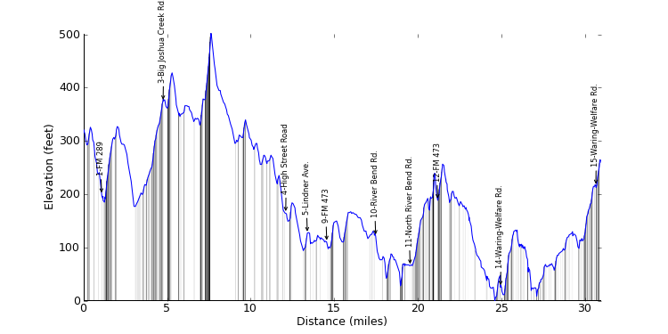
| Ride Analysis | |||
|---|---|---|---|
| elevation change (feet) | distance (miles) | avg. grade (%) | |
| Climbing | 2080.23 | 13.00 | 3.0 |
| Descending | -2136.42 | 17.97 | -2.3 |
| Overall | 4216.65 | 30.96 | |
| Top 10 Climbs: | ||
|---|---|---|
| Rank | Gradient (%) | Distance (miles) |
| 1 | 5.6 | 0.42 |
| 2 | 3.7 | 0.62 |
| 3 | 3.3 | 0.80 |
| 4 | 2.8 | 0.70 |
| 5 | 2.7 | 0.40 |
| 6 | 2.4 | 0.96 |
| 7 | 1.3 | 0.45 |
| 8 | 1.2 | 0.41 |
| 9 | 1.1 | 0.56 |
| 10 | 0.6 | 0.38 |
| Segment Analysis | |||
|---|---|---|---|
| elevation change (feet) | distance (miles) | avg. grade (%) | |
| Climbing | 45.93 | 0.27 | 3.2 |
| Descending | -162.72 | 0.81 | -3.8 |
| Overall | 208.65 | 1.08 | |
| Top 10 Climbs: | ||
|---|---|---|
| Rank | Gradient (%) | Distance (miles) |
| 1 | 3.4 | 0.03 |
| 2 | 3.1 | 0.20 |
| Segment Analysis | |||
|---|---|---|---|
| elevation change (feet) | distance (miles) | avg. grade (%) | |
| Climbing | 3.28 | 0.02 | 2.9 |
| Descending | -14.38 | 0.07 | -3.9 |
| Overall | 17.66 | 0.09 | |
| Segment Analysis | |||
|---|---|---|---|
| elevation change (feet) | distance (miles) | avg. grade (%) | |
| Climbing | 350.80 | 2.25 | 3.0 |
| Descending | -165.03 | 1.34 | -2.3 |
| Overall | 515.83 | 3.59 | |
| Top 10 Climbs: | ||
|---|---|---|
| Rank | Gradient (%) | Distance (miles) |
| 1 | 3.3 | 0.80 |
| 2 | 1.8 | 0.19 |
| 3 | 1.2 | 0.41 |
| Segment Analysis | |||
|---|---|---|---|
| elevation change (feet) | distance (miles) | avg. grade (%) | |
| Climbing | 423.23 | 2.27 | 3.5 |
| Descending | -632.46 | 5.06 | -2.4 |
| Overall | 1055.69 | 7.33 | |
| Top 10 Climbs: | ||
|---|---|---|
| Rank | Gradient (%) | Distance (miles) |
| 1 | 5.6 | 0.42 |
| 2 | 4.6 | 0.17 |
| 3 | 3.7 | 0.32 |
| 4 | 2.6 | 0.22 |
| 5 | 2.3 | 0.13 |
| 6 | 1.6 | 0.13 |
| 7 | 1.5 | 0.20 |
| 8 | 1.1 | 0.19 |
| 9 | 0.9 | 0.17 |
| 10 | 0.2 | 0.14 |
| Segment Analysis | |||
|---|---|---|---|
| elevation change (feet) | distance (miles) | avg. grade (%) | |
| Climbing | 70.42 | 0.43 | 3.1 |
| Descending | -108.60 | 0.86 | -2.4 |
| Overall | 179.02 | 1.29 | |
| Top 10 Climbs: | ||
|---|---|---|
| Rank | Gradient (%) | Distance (miles) |
| 1 | 2.4 | 0.26 |
| Segment Analysis | |||
|---|---|---|---|
| elevation change (feet) | distance (miles) | avg. grade (%) | |
| Climbing | 2.62 | 0.04 | 1.2 |
| Descending | -1.99 | 0.12 | -0.3 |
| Overall | 4.62 | 0.16 | |
| Top 10 Climbs: | ||
|---|---|---|
| Rank | Gradient (%) | Distance (miles) |
| 1 | 0.4 | 0.06 |
| Segment Analysis | |||
|---|---|---|---|
| elevation change (feet) | distance (miles) | avg. grade (%) | |
| Climbing | 0.00 | 0.00 | 0.0 |
| Descending | -21.12 | 0.04 | -10.6 |
| Overall | 21.12 | 0.04 | |
| Segment Analysis | |||
|---|---|---|---|
| elevation change (feet) | distance (miles) | avg. grade (%) | |
| Climbing | 10.42 | 0.08 | 2.3 |
| Descending | -3.28 | 0.14 | -0.5 |
| Overall | 13.70 | 0.22 | |
| Top 10 Climbs: | ||
|---|---|---|
| Rank | Gradient (%) | Distance (miles) |
| 1 | 0.7 | 0.05 |
| Segment Analysis | |||
|---|---|---|---|
| elevation change (feet) | distance (miles) | avg. grade (%) | |
| Climbing | 18.70 | 0.20 | 1.8 |
| Descending | -21.65 | 0.54 | -0.8 |
| Overall | 40.35 | 0.74 | |
| Top 10 Climbs: | ||
|---|---|---|
| Rank | Gradient (%) | Distance (miles) |
| 1 | 1.9 | 0.13 |
| 2 | 1.0 | 0.06 |
| Segment Analysis | |||
|---|---|---|---|
| elevation change (feet) | distance (miles) | avg. grade (%) | |
| Climbing | 134.51 | 1.15 | 2.2 |
| Descending | -123.78 | 1.78 | -1.3 |
| Overall | 258.30 | 2.93 | |
| Top 10 Climbs: | ||
|---|---|---|
| Rank | Gradient (%) | Distance (miles) |
| 1 | 3.2 | 0.29 |
| 2 | 2.7 | 0.40 |
| 3 | 0.6 | 0.38 |
| 4 | 0.4 | 0.07 |
| 5 | 0.3 | 0.10 |
| Segment Analysis | |||
|---|---|---|---|
| elevation change (feet) | distance (miles) | avg. grade (%) | |
| Climbing | 117.97 | 0.73 | 3.0 |
| Descending | -173.23 | 1.33 | -2.5 |
| Overall | 291.20 | 2.06 | |
| Top 10 Climbs: | ||
|---|---|---|
| Rank | Gradient (%) | Distance (miles) |
| 1 | 20.5 | 0.00 |
| 2 | 4.5 | 0.18 |
| 3 | 2.8 | 0.31 |
| 4 | 2.3 | 0.01 |
| 5 | 1.2 | 0.03 |
| 6 | 0.9 | 0.16 |
| Segment Analysis | |||
|---|---|---|---|
| elevation change (feet) | distance (miles) | avg. grade (%) | |
| Climbing | 203.08 | 1.12 | 3.4 |
| Descending | -80.32 | 0.53 | -2.9 |
| Overall | 283.41 | 1.65 | |
| Top 10 Climbs: | ||
|---|---|---|
| Rank | Gradient (%) | Distance (miles) |
| 1 | 4.6 | 0.09 |
| 2 | 4.1 | 0.20 |
| 3 | 2.4 | 0.96 |
| 4 | 0.6 | 0.05 |
| Segment Analysis | |||
|---|---|---|---|
| elevation change (feet) | distance (miles) | avg. grade (%) | |
| Climbing | 68.47 | 0.30 | 4.3 |
| Descending | -1.64 | 0.01 | -3.3 |
| Overall | 70.11 | 0.31 | |
| Segment Analysis | |||
|---|---|---|---|
| elevation change (feet) | distance (miles) | avg. grade (%) | |
| Climbing | 116.09 | 0.86 | 2.5 |
| Descending | -345.80 | 2.58 | -2.5 |
| Overall | 461.89 | 3.44 | |
| Top 10 Climbs: | ||
|---|---|---|
| Rank | Gradient (%) | Distance (miles) |
| 1 | 1.8 | 0.05 |
| 2 | 1.8 | 0.22 |
| 3 | 1.0 | 0.06 |
| 4 | 0.8 | 0.08 |
| 5 | 0.7 | 0.05 |
| 6 | 0.6 | 0.14 |
| 7 | 0.4 | 0.08 |
| Segment Analysis | |||
|---|---|---|---|
| elevation change (feet) | distance (miles) | avg. grade (%) | |
| Climbing | 460.63 | 3.01 | 2.9 |
| Descending | -270.58 | 2.69 | -1.9 |
| Overall | 731.21 | 5.70 | |
| Top 10 Climbs: | ||
|---|---|---|
| Rank | Gradient (%) | Distance (miles) |
| 1 | 3.7 | 0.62 |
| 2 | 2.8 | 0.70 |
| 3 | 2.6 | 0.19 |
| 4 | 2.5 | 0.22 |
| 5 | 1.8 | 0.18 |
| 6 | 1.3 | 0.45 |
| 7 | 1.1 | 0.56 |
| 8 | 0.5 | 0.33 |
| 9 | 0.5 | 0.12 |
| 10 | 0.0 | 0.18 |
| Segment Analysis | |||
|---|---|---|---|
| elevation change (feet) | distance (miles) | avg. grade (%) | |
| Climbing | 52.42 | 0.25 | 4.0 |
| Descending | -3.28 | 0.01 | -4.2 |
| Overall | 55.70 | 0.26 | |
| Segment Analysis | |||
|---|---|---|---|
| elevation change (feet) | distance (miles) | avg. grade (%) | |
| Climbing | 1.64 | 0.00 | 173.0 |
| Descending | -6.56 | 0.06 | -2.2 |
| Overall | 8.20 | 0.06 | |
| Ride Analysis | |||
|---|---|---|---|
| elevation change (feet) | distance (miles) | avg. grade (%) | |
| Climbing | 3620.00 | 23.63 | 2.9 |
| Descending | -3698.37 | 34.34 | -2.0 |
| Overall | 7318.37 | 57.97 | |
| Top 10 Climbs: | ||
|---|---|---|
| Rank | Gradient (%) | Distance (miles) |
| 1 | 3.7 | 0.62 |
| 2 | 3.3 | 0.80 |
| 3 | 2.8 | 0.70 |
| 4 | 2.4 | 0.96 |
| 5 | 2.4 | 0.66 |
| 6 | 2.4 | 0.77 |
| 7 | 2.3 | 0.61 |
| 8 | 2.0 | 0.86 |
| 9 | 1.1 | 0.56 |
| 10 | 0.3 | 0.63 |
| Segment Analysis | |||
|---|---|---|---|
| elevation change (feet) | distance (miles) | avg. grade (%) | |
| Climbing | 45.93 | 0.27 | 3.2 |
| Descending | -162.72 | 0.81 | -3.8 |
| Overall | 208.65 | 1.08 | |
| Top 10 Climbs: | ||
|---|---|---|
| Rank | Gradient (%) | Distance (miles) |
| 1 | 3.4 | 0.03 |
| 2 | 3.1 | 0.20 |
| Segment Analysis | |||
|---|---|---|---|
| elevation change (feet) | distance (miles) | avg. grade (%) | |
| Climbing | 3.28 | 0.02 | 2.9 |
| Descending | -14.38 | 0.07 | -3.9 |
| Overall | 17.66 | 0.09 | |
| Segment Analysis | |||
|---|---|---|---|
| elevation change (feet) | distance (miles) | avg. grade (%) | |
| Climbing | 350.80 | 2.25 | 3.0 |
| Descending | -165.03 | 1.34 | -2.3 |
| Overall | 515.83 | 3.59 | |
| Top 10 Climbs: | ||
|---|---|---|
| Rank | Gradient (%) | Distance (miles) |
| 1 | 3.3 | 0.80 |
| 2 | 1.8 | 0.19 |
| 3 | 1.2 | 0.41 |

| Segment Analysis | |||
|---|---|---|---|
| elevation change (feet) | distance (miles) | avg. grade (%) | |
| Climbing | 423.23 | 2.27 | 3.5 |
| Descending | -632.46 | 5.06 | -2.4 |
| Overall | 1055.69 | 7.33 | |
| Top 10 Climbs: | ||
|---|---|---|
| Rank | Gradient (%) | Distance (miles) |
| 1 | 5.6 | 0.42 |
| 2 | 4.6 | 0.17 |
| 3 | 3.7 | 0.32 |
| 4 | 2.6 | 0.22 |
| 5 | 2.3 | 0.13 |
| 6 | 1.6 | 0.13 |
| 7 | 1.5 | 0.20 |
| 8 | 1.1 | 0.19 |
| 9 | 0.9 | 0.17 |
| 10 | 0.2 | 0.14 |
| Segment Analysis | |||
|---|---|---|---|
| elevation change (feet) | distance (miles) | avg. grade (%) | |
| Climbing | 87.05 | 0.66 | 2.5 |
| Descending | -125.98 | 1.29 | -1.9 |
| Overall | 213.03 | 1.95 | |
| Top 10 Climbs: | ||
|---|---|---|
| Rank | Gradient (%) | Distance (miles) |
| 1 | 2.4 | 0.26 |
| 2 | 1.8 | 0.31 |
| 3 | 1.0 | 0.06 |
| 4 | 0.8 | 0.12 |
| 5 | 0.6 | 0.06 |
| Segment Analysis | |||
|---|---|---|---|
| elevation change (feet) | distance (miles) | avg. grade (%) | |
| Climbing | 3.01 | 0.05 | 1.1 |
| Descending | -7.55 | 0.16 | -0.9 |
| Overall | 10.55 | 0.21 | |
| Top 10 Climbs: | ||
|---|---|---|
| Rank | Gradient (%) | Distance (miles) |
| 1 | 0.5 | 0.05 |
| Segment Analysis | |||
|---|---|---|---|
| elevation change (feet) | distance (miles) | avg. grade (%) | |
| Climbing | 161.09 | 1.37 | 2.2 |
| Descending | -44.80 | 0.71 | -1.2 |
| Overall | 205.89 | 2.08 | |
| Top 10 Climbs: | ||
|---|---|---|
| Rank | Gradient (%) | Distance (miles) |
| 1 | 2.6 | 0.19 |
| 2 | 2.0 | 0.86 |
| 3 | 0.6 | 0.36 |
| 4 | 0.4 | 0.31 |
| Segment Analysis | |||
|---|---|---|---|
| elevation change (feet) | distance (miles) | avg. grade (%) | |
| Climbing | 0.00 | 0.00 | 0.0 |
| Descending | -69.09 | 0.90 | -1.5 |
| Overall | 69.09 | 0.90 | |
| Segment Analysis | |||
|---|---|---|---|
| elevation change (feet) | distance (miles) | avg. grade (%) | |
| Climbing | 246.20 | 1.77 | 2.6 |
| Descending | -240.81 | 2.45 | -1.9 |
| Overall | 487.02 | 4.23 | |
| Top 10 Climbs: | ||
|---|---|---|
| Rank | Gradient (%) | Distance (miles) |
| 1 | 2.7 | 0.02 |
| 2 | 2.4 | 0.77 |
| 3 | 2.3 | 0.61 |
| 4 | 2.3 | 0.23 |
| 5 | 1.7 | 0.04 |
| 6 | 1.1 | 0.08 |
| 7 | 1.1 | 0.17 |
| 8 | 0.6 | 0.11 |
| Segment Analysis | |||
|---|---|---|---|
| elevation change (feet) | distance (miles) | avg. grade (%) | |
| Climbing | 36.45 | 0.61 | 1.1 |
| Descending | -21.98 | 0.63 | -0.7 |
| Overall | 58.43 | 1.24 | |
| Top 10 Climbs: | ||
|---|---|---|
| Rank | Gradient (%) | Distance (miles) |
| 1 | 1.1 | 0.28 |
| 2 | 0.3 | 0.63 |
| 3 | 0.3 | 0.12 |
| Segment Analysis | |||
|---|---|---|---|
| elevation change (feet) | distance (miles) | avg. grade (%) | |
| Climbing | 94.16 | 1.05 | 1.7 |
| Descending | -63.18 | 0.95 | -1.3 |
| Overall | 157.34 | 2.00 | |
| Top 10 Climbs: | ||
|---|---|---|
| Rank | Gradient (%) | Distance (miles) |
| 1 | 2.6 | 0.22 |
| 2 | 1.5 | 0.12 |
| 3 | 1.0 | 0.53 |
| 4 | 0.9 | 0.35 |
| 5 | 0.5 | 0.05 |
| Segment Analysis | |||
|---|---|---|---|
| elevation change (feet) | distance (miles) | avg. grade (%) | |
| Climbing | 9.19 | 0.17 | 1.0 |
| Descending | -27.05 | 0.40 | -1.3 |
| Overall | 36.23 | 0.57 | |
| Top 10 Climbs: | ||
|---|---|---|
| Rank | Gradient (%) | Distance (miles) |
| 1 | 1.6 | 0.02 |
| Segment Analysis | |||
|---|---|---|---|
| elevation change (feet) | distance (miles) | avg. grade (%) | |
| Climbing | 3.28 | 0.06 | 1.0 |
| Descending | -9.51 | 0.23 | -0.8 |
| Overall | 12.80 | 0.29 | |
| Segment Analysis | |||
|---|---|---|---|
| elevation change (feet) | distance (miles) | avg. grade (%) | |
| Climbing | 546.59 | 2.49 | 4.2 |
| Descending | -308.99 | 2.28 | -2.6 |
| Overall | 855.58 | 4.77 | |
| Top 10 Climbs: | ||
|---|---|---|
| Rank | Gradient (%) | Distance (miles) |
| 1 | 6.7 | 0.35 |
| 2 | 5.4 | 0.12 |
| 3 | 4.9 | 0.26 |
| 4 | 3.0 | 0.12 |
| 5 | 2.9 | 0.15 |
| 6 | 2.4 | 0.66 |
| 7 | 2.2 | 0.15 |
| 8 | 0.9 | 0.55 |
| 9 | 0.7 | 0.25 |
| 10 | 0.6 | 0.24 |
| Segment Analysis | |||
|---|---|---|---|
| elevation change (feet) | distance (miles) | avg. grade (%) | |
| Climbing | 80.71 | 0.52 | 3.0 |
| Descending | -292.24 | 1.92 | -2.9 |
| Overall | 372.95 | 2.44 | |
| Top 10 Climbs: | ||
|---|---|---|
| Rank | Gradient (%) | Distance (miles) |
| 1 | 3.1 | 0.06 |
| 2 | 2.4 | 0.17 |
| 3 | 1.6 | 0.18 |
| 4 | 1.2 | 0.03 |
| 5 | 0.7 | 0.09 |
| Segment Analysis | |||
|---|---|---|---|
| elevation change (feet) | distance (miles) | avg. grade (%) | |
| Climbing | 13.51 | 0.06 | 4.5 |
| Descending | -1.64 | 0.01 | -3.5 |
| Overall | 15.15 | 0.07 | |
| Segment Analysis | |||
|---|---|---|---|
| elevation change (feet) | distance (miles) | avg. grade (%) | |
| Climbing | 150.29 | 0.83 | 3.4 |
| Descending | -135.50 | 1.56 | -1.6 |
| Overall | 285.79 | 2.39 | |
| Top 10 Climbs: | ||
|---|---|---|
| Rank | Gradient (%) | Distance (miles) |
| 1 | 3.8 | 0.05 |
| 2 | 2.6 | 0.16 |
| 3 | 2.5 | 0.15 |
| 4 | 2.4 | 0.25 |
| 5 | 1.4 | 0.07 |
| 6 | 1.3 | 0.21 |
| 7 | 0.5 | 0.18 |
| 8 | 0.5 | 0.07 |
| Segment Analysis | |||
|---|---|---|---|
| elevation change (feet) | distance (miles) | avg. grade (%) | |
| Climbing | 82.35 | 0.36 | 4.4 |
| Descending | -186.04 | 1.68 | -2.1 |
| Overall | 268.39 | 2.04 | |
| Top 10 Climbs: | ||
|---|---|---|
| Rank | Gradient (%) | Distance (miles) |
| 1 | 4.2 | 0.15 |
| 2 | 4.0 | 0.13 |
| 3 | 1.4 | 0.05 |
| 4 | 0.3 | 0.11 |
| Segment Analysis | |||
|---|---|---|---|
| elevation change (feet) | distance (miles) | avg. grade (%) | |
| Climbing | 41.38 | 0.56 | 1.4 |
| Descending | -68.57 | 1.12 | -1.2 |
| Overall | 109.95 | 1.69 | |
| Top 10 Climbs: | ||
|---|---|---|
| Rank | Gradient (%) | Distance (miles) |
| 1 | 1.0 | 0.06 |
| 2 | 0.7 | 0.05 |
| 3 | 0.6 | 0.05 |
| 4 | 0.4 | 0.21 |
| 5 | 0.2 | 0.29 |
| 6 | 0.2 | 0.17 |
| Segment Analysis | |||
|---|---|---|---|
| elevation change (feet) | distance (miles) | avg. grade (%) | |
| Climbing | 23.95 | 0.22 | 2.1 |
| Descending | -41.03 | 0.37 | -2.1 |
| Overall | 64.98 | 0.58 | |
| Top 10 Climbs: | ||
|---|---|---|
| Rank | Gradient (%) | Distance (miles) |
| 1 | 1.3 | 0.25 |
| 2 | 1.0 | 0.03 |
| Segment Analysis | |||
|---|---|---|---|
| elevation change (feet) | distance (miles) | avg. grade (%) | |
| Climbing | 12.80 | 0.10 | 2.5 |
| Descending | -4.92 | 0.10 | -0.9 |
| Overall | 17.72 | 0.20 | |
| Top 10 Climbs: | ||
|---|---|---|
| Rank | Gradient (%) | Distance (miles) |
| 1 | 0.9 | 0.09 |
| Segment Analysis | |||
|---|---|---|---|
| elevation change (feet) | distance (miles) | avg. grade (%) | |
| Climbing | 18.19 | 0.19 | 1.8 |
| Descending | -21.65 | 0.47 | -0.9 |
| Overall | 39.85 | 0.67 | |
| Top 10 Climbs: | ||
|---|---|---|
| Rank | Gradient (%) | Distance (miles) |
| 1 | 2.3 | 0.02 |
| 2 | 0.5 | 0.12 |
| 3 | 0.5 | 0.07 |
| 4 | 0.4 | 0.07 |

| Segment Analysis | |||
|---|---|---|---|
| elevation change (feet) | distance (miles) | avg. grade (%) | |
| Climbing | 2.62 | 0.04 | 1.2 |
| Descending | -1.99 | 0.12 | -0.3 |
| Overall | 4.62 | 0.16 | |
| Top 10 Climbs: | ||
|---|---|---|
| Rank | Gradient (%) | Distance (miles) |
| 1 | 0.4 | 0.06 |
| Segment Analysis | |||
|---|---|---|---|
| elevation change (feet) | distance (miles) | avg. grade (%) | |
| Climbing | 0.00 | 0.00 | 0.0 |
| Descending | -21.12 | 0.04 | -10.6 |
| Overall | 21.12 | 0.04 | |
| Segment Analysis | |||
|---|---|---|---|
| elevation change (feet) | distance (miles) | avg. grade (%) | |
| Climbing | 10.42 | 0.08 | 2.3 |
| Descending | -3.28 | 0.14 | -0.5 |
| Overall | 13.70 | 0.22 | |
| Top 10 Climbs: | ||
|---|---|---|
| Rank | Gradient (%) | Distance (miles) |
| 1 | 0.7 | 0.05 |
| Segment Analysis | |||
|---|---|---|---|
| elevation change (feet) | distance (miles) | avg. grade (%) | |
| Climbing | 18.70 | 0.20 | 1.8 |
| Descending | -21.65 | 0.54 | -0.8 |
| Overall | 40.35 | 0.74 | |
| Top 10 Climbs: | ||
|---|---|---|
| Rank | Gradient (%) | Distance (miles) |
| 1 | 1.9 | 0.13 |
| 2 | 1.0 | 0.06 |
| Segment Analysis | |||
|---|---|---|---|
| elevation change (feet) | distance (miles) | avg. grade (%) | |
| Climbing | 134.51 | 1.15 | 2.2 |
| Descending | -123.78 | 1.78 | -1.3 |
| Overall | 258.30 | 2.93 | |
| Top 10 Climbs: | ||
|---|---|---|
| Rank | Gradient (%) | Distance (miles) |
| 1 | 3.2 | 0.29 |
| 2 | 2.7 | 0.40 |
| 3 | 0.6 | 0.38 |
| 4 | 0.4 | 0.07 |
| 5 | 0.3 | 0.10 |
| Segment Analysis | |||
|---|---|---|---|
| elevation change (feet) | distance (miles) | avg. grade (%) | |
| Climbing | 117.97 | 0.73 | 3.0 |
| Descending | -173.23 | 1.33 | -2.5 |
| Overall | 291.20 | 2.06 | |
| Top 10 Climbs: | ||
|---|---|---|
| Rank | Gradient (%) | Distance (miles) |
| 1 | 20.5 | 0.00 |
| 2 | 4.5 | 0.18 |
| 3 | 2.8 | 0.31 |
| 4 | 2.3 | 0.01 |
| 5 | 1.2 | 0.03 |
| 6 | 0.9 | 0.16 |
| Segment Analysis | |||
|---|---|---|---|
| elevation change (feet) | distance (miles) | avg. grade (%) | |
| Climbing | 203.08 | 1.12 | 3.4 |
| Descending | -80.32 | 0.53 | -2.9 |
| Overall | 283.41 | 1.65 | |
| Top 10 Climbs: | ||
|---|---|---|
| Rank | Gradient (%) | Distance (miles) |
| 1 | 4.6 | 0.09 |
| 2 | 4.1 | 0.20 |
| 3 | 2.4 | 0.96 |
| 4 | 0.6 | 0.05 |
| Segment Analysis | |||
|---|---|---|---|
| elevation change (feet) | distance (miles) | avg. grade (%) | |
| Climbing | 68.47 | 0.30 | 4.3 |
| Descending | -1.64 | 0.01 | -3.3 |
| Overall | 70.11 | 0.31 | |
| Segment Analysis | |||
|---|---|---|---|
| elevation change (feet) | distance (miles) | avg. grade (%) | |
| Climbing | 116.09 | 0.86 | 2.5 |
| Descending | -345.80 | 2.58 | -2.5 |
| Overall | 461.89 | 3.44 | |
| Top 10 Climbs: | ||
|---|---|---|
| Rank | Gradient (%) | Distance (miles) |
| 1 | 1.8 | 0.05 |
| 2 | 1.8 | 0.22 |
| 3 | 1.0 | 0.06 |
| 4 | 0.8 | 0.08 |
| 5 | 0.7 | 0.05 |
| 6 | 0.6 | 0.14 |
| 7 | 0.4 | 0.08 |
| Segment Analysis | |||
|---|---|---|---|
| elevation change (feet) | distance (miles) | avg. grade (%) | |
| Climbing | 460.63 | 3.01 | 2.9 |
| Descending | -270.58 | 2.69 | -1.9 |
| Overall | 731.21 | 5.70 | |
| Top 10 Climbs: | ||
|---|---|---|
| Rank | Gradient (%) | Distance (miles) |
| 1 | 3.7 | 0.62 |
| 2 | 2.8 | 0.70 |
| 3 | 2.6 | 0.19 |
| 4 | 2.5 | 0.22 |
| 5 | 1.8 | 0.18 |
| 6 | 1.3 | 0.45 |
| 7 | 1.1 | 0.56 |
| 8 | 0.5 | 0.33 |
| 9 | 0.5 | 0.12 |
| 10 | 0.0 | 0.18 |
| Segment Analysis | |||
|---|---|---|---|
| elevation change (feet) | distance (miles) | avg. grade (%) | |
| Climbing | 52.42 | 0.25 | 4.0 |
| Descending | -3.28 | 0.01 | -4.2 |
| Overall | 55.70 | 0.26 | |
| Segment Analysis | |||
|---|---|---|---|
| elevation change (feet) | distance (miles) | avg. grade (%) | |
| Climbing | 1.64 | 0.00 | 173.0 |
| Descending | -6.56 | 0.06 | -2.2 |
| Overall | 8.20 | 0.06 | |
| Ride Analysis | |||
|---|---|---|---|
| elevation change (feet) | distance (miles) | avg. grade (%) | |
| Climbing | 4048.90 | 29.35 | 2.6 |
| Descending | -4154.51 | 42.60 | -1.8 |
| Overall | 8203.41 | 71.95 | |
| Top 10 Climbs: | ||
|---|---|---|
| Rank | Gradient (%) | Distance (miles) |
| 1 | 3.7 | 0.62 |
| 2 | 3.3 | 0.80 |
| 3 | 2.8 | 0.70 |
| 4 | 2.4 | 0.96 |
| 5 | 2.4 | 0.77 |
| 6 | 2.3 | 1.06 |
| 7 | 2.3 | 0.61 |
| 8 | 2.0 | 0.86 |
| 9 | 1.3 | 0.67 |
| 10 | 0.3 | 0.63 |
| Segment Analysis | |||
|---|---|---|---|
| elevation change (feet) | distance (miles) | avg. grade (%) | |
| Climbing | 45.93 | 0.27 | 3.2 |
| Descending | -162.72 | 0.81 | -3.8 |
| Overall | 208.65 | 1.08 | |
| Top 10 Climbs: | ||
|---|---|---|
| Rank | Gradient (%) | Distance (miles) |
| 1 | 3.4 | 0.03 |
| 2 | 3.1 | 0.20 |
| Segment Analysis | |||
|---|---|---|---|
| elevation change (feet) | distance (miles) | avg. grade (%) | |
| Climbing | 3.28 | 0.02 | 2.9 |
| Descending | -14.38 | 0.07 | -3.9 |
| Overall | 17.66 | 0.09 | |
| Segment Analysis | |||
|---|---|---|---|
| elevation change (feet) | distance (miles) | avg. grade (%) | |
| Climbing | 350.80 | 2.25 | 3.0 |
| Descending | -165.03 | 1.34 | -2.3 |
| Overall | 515.83 | 3.59 | |
| Top 10 Climbs: | ||
|---|---|---|
| Rank | Gradient (%) | Distance (miles) |
| 1 | 3.3 | 0.80 |
| 2 | 1.8 | 0.19 |
| 3 | 1.2 | 0.41 |
| Segment Analysis | |||
|---|---|---|---|
| elevation change (feet) | distance (miles) | avg. grade (%) | |
| Climbing | 423.23 | 2.27 | 3.5 |
| Descending | -632.46 | 5.06 | -2.4 |
| Overall | 1055.69 | 7.33 | |
| Top 10 Climbs: | ||
|---|---|---|
| Rank | Gradient (%) | Distance (miles) |
| 1 | 5.6 | 0.42 |
| 2 | 4.6 | 0.17 |
| 3 | 3.7 | 0.32 |
| 4 | 2.6 | 0.22 |
| 5 | 2.3 | 0.13 |
| 6 | 1.6 | 0.13 |
| 7 | 1.5 | 0.20 |
| 8 | 1.1 | 0.19 |
| 9 | 0.9 | 0.17 |
| 10 | 0.2 | 0.14 |
| Segment Analysis | |||
|---|---|---|---|
| elevation change (feet) | distance (miles) | avg. grade (%) | |
| Climbing | 87.05 | 0.66 | 2.5 |
| Descending | -125.98 | 1.29 | -1.9 |
| Overall | 213.03 | 1.95 | |
| Top 10 Climbs: | ||
|---|---|---|
| Rank | Gradient (%) | Distance (miles) |
| 1 | 2.4 | 0.26 |
| 2 | 1.8 | 0.31 |
| 3 | 1.0 | 0.06 |
| 4 | 0.8 | 0.12 |
| 5 | 0.6 | 0.06 |
| Segment Analysis | |||
|---|---|---|---|
| elevation change (feet) | distance (miles) | avg. grade (%) | |
| Climbing | 3.01 | 0.05 | 1.1 |
| Descending | -7.55 | 0.16 | -0.9 |
| Overall | 10.55 | 0.21 | |
| Top 10 Climbs: | ||
|---|---|---|
| Rank | Gradient (%) | Distance (miles) |
| 1 | 0.5 | 0.05 |
| Segment Analysis | |||
|---|---|---|---|
| elevation change (feet) | distance (miles) | avg. grade (%) | |
| Climbing | 161.09 | 1.37 | 2.2 |
| Descending | -44.80 | 0.71 | -1.2 |
| Overall | 205.89 | 2.08 | |
| Top 10 Climbs: | ||
|---|---|---|
| Rank | Gradient (%) | Distance (miles) |
| 1 | 2.6 | 0.19 |
| 2 | 2.0 | 0.86 |
| 3 | 0.6 | 0.36 |
| 4 | 0.4 | 0.31 |
| Segment Analysis | |||
|---|---|---|---|
| elevation change (feet) | distance (miles) | avg. grade (%) | |
| Climbing | 0.00 | 0.00 | 0.0 |
| Descending | -69.09 | 0.90 | -1.5 |
| Overall | 69.09 | 0.90 | |
| Segment Analysis | |||
|---|---|---|---|
| elevation change (feet) | distance (miles) | avg. grade (%) | |
| Climbing | 246.20 | 1.77 | 2.6 |
| Descending | -240.81 | 2.45 | -1.9 |
| Overall | 487.02 | 4.23 | |
| Top 10 Climbs: | ||
|---|---|---|
| Rank | Gradient (%) | Distance (miles) |
| 1 | 2.7 | 0.02 |
| 2 | 2.4 | 0.77 |
| 3 | 2.3 | 0.61 |
| 4 | 2.3 | 0.23 |
| 5 | 1.7 | 0.04 |
| 6 | 1.1 | 0.08 |
| 7 | 1.1 | 0.17 |
| 8 | 0.6 | 0.11 |

| Segment Analysis | |||
|---|---|---|---|
| elevation change (feet) | distance (miles) | avg. grade (%) | |
| Climbing | 36.45 | 0.61 | 1.1 |
| Descending | -21.98 | 0.63 | -0.7 |
| Overall | 58.43 | 1.24 | |
| Top 10 Climbs: | ||
|---|---|---|
| Rank | Gradient (%) | Distance (miles) |
| 1 | 1.1 | 0.28 |
| 2 | 0.3 | 0.63 |
| 3 | 0.3 | 0.12 |
| Segment Analysis | |||
|---|---|---|---|
| elevation change (feet) | distance (miles) | avg. grade (%) | |
| Climbing | 94.16 | 1.05 | 1.7 |
| Descending | -63.18 | 0.94 | -1.3 |
| Overall | 157.34 | 2.00 | |
| Top 10 Climbs: | ||
|---|---|---|
| Rank | Gradient (%) | Distance (miles) |
| 1 | 2.6 | 0.22 |
| 2 | 1.5 | 0.12 |
| 3 | 1.0 | 0.53 |
| 4 | 0.9 | 0.35 |
| 5 | 0.5 | 0.05 |
| Segment Analysis | |||
|---|---|---|---|
| elevation change (feet) | distance (miles) | avg. grade (%) | |
| Climbing | 1.64 | 0.02 | 2.0 |
| Descending | -6.04 | 0.18 | -0.6 |
| Overall | 7.68 | 0.20 | |
| Segment Analysis | |||
|---|---|---|---|
| elevation change (feet) | distance (miles) | avg. grade (%) | |
| Climbing | 3.28 | 0.00 | 24.0 |
| Descending | -23.73 | 0.15 | -3.1 |
| Overall | 27.01 | 0.15 | |
| Segment Analysis | |||
|---|---|---|---|
| elevation change (feet) | distance (miles) | avg. grade (%) | |
| Climbing | 142.24 | 1.82 | 1.5 |
| Descending | -88.91 | 1.90 | -0.9 |
| Overall | 231.15 | 3.71 | |
| Top 10 Climbs: | ||
|---|---|---|
| Rank | Gradient (%) | Distance (miles) |
| 1 | 2.0 | 0.32 |
| 2 | 1.6 | 0.28 |
| 3 | 1.2 | 0.10 |
| 4 | 0.9 | 0.23 |
| 5 | 0.9 | 0.45 |
| 6 | 0.5 | 0.49 |
| 7 | 0.4 | 0.08 |
| 8 | 0.2 | 0.42 |
| 9 | 0.2 | 0.16 |
| Segment Analysis | |||
|---|---|---|---|
| elevation change (feet) | distance (miles) | avg. grade (%) | |
| Climbing | 99.74 | 0.84 | 2.3 |
| Descending | -33.85 | 1.23 | -0.5 |
| Overall | 133.59 | 2.06 | |
| Top 10 Climbs: | ||
|---|---|---|
| Rank | Gradient (%) | Distance (miles) |
| 1 | 5.5 | 0.24 |
| 2 | 0.9 | 0.13 |
| 3 | 0.5 | 0.34 |
| 4 | 0.2 | 0.14 |
| 5 | 0.2 | 0.18 |
| Segment Analysis | |||
|---|---|---|---|
| elevation change (feet) | distance (miles) | avg. grade (%) | |
| Climbing | 56.76 | 1.15 | 0.9 |
| Descending | -93.56 | 1.61 | -1.1 |
| Overall | 150.31 | 2.76 | |
| Top 10 Climbs: | ||
|---|---|---|
| Rank | Gradient (%) | Distance (miles) |
| 1 | 0.7 | 0.32 |
| 2 | 0.6 | 0.33 |
| 3 | 0.5 | 0.20 |
| 4 | 0.5 | 0.45 |
| 5 | 0.3 | 0.28 |
| Segment Analysis | |||
|---|---|---|---|
| elevation change (feet) | distance (miles) | avg. grade (%) | |
| Climbing | 244.42 | 1.86 | 2.5 |
| Descending | -57.07 | 1.30 | -0.8 |
| Overall | 301.49 | 3.15 | |
| Top 10 Climbs: | ||
|---|---|---|
| Rank | Gradient (%) | Distance (miles) |
| 1 | 2.7 | 0.52 |
| 2 | 2.3 | 1.06 |
| 3 | 1.7 | 0.40 |
| 4 | 0.3 | 0.09 |
| Segment Analysis | |||
|---|---|---|---|
| elevation change (feet) | distance (miles) | avg. grade (%) | |
| Climbing | 684.38 | 4.18 | 3.1 |
| Descending | -927.91 | 8.31 | -2.1 |
| Overall | 1612.29 | 12.49 | |
| Top 10 Climbs: | ||
|---|---|---|
| Rank | Gradient (%) | Distance (miles) |
| 1 | 5.7 | 0.48 |
| 2 | 3.7 | 0.18 |
| 3 | 2.7 | 0.19 |
| 4 | 1.6 | 0.32 |
| 5 | 1.3 | 0.67 |
| 6 | 0.5 | 0.18 |
| 7 | 0.4 | 0.22 |
| 8 | 0.4 | 0.23 |
| 9 | 0.2 | 0.18 |
| 10 | 0.1 | 0.25 |
| Segment Analysis | |||
|---|---|---|---|
| elevation change (feet) | distance (miles) | avg. grade (%) | |
| Climbing | 82.35 | 0.36 | 4.4 |
| Descending | -186.04 | 1.68 | -2.1 |
| Overall | 268.39 | 2.04 | |
| Top 10 Climbs: | ||
|---|---|---|
| Rank | Gradient (%) | Distance (miles) |
| 1 | 4.2 | 0.15 |
| 2 | 4.0 | 0.13 |
| 3 | 1.4 | 0.05 |
| 4 | 0.3 | 0.11 |
| Segment Analysis | |||
|---|---|---|---|
| elevation change (feet) | distance (miles) | avg. grade (%) | |
| Climbing | 41.38 | 0.56 | 1.4 |
| Descending | -68.57 | 1.12 | -1.2 |
| Overall | 109.95 | 1.69 | |
| Top 10 Climbs: | ||
|---|---|---|
| Rank | Gradient (%) | Distance (miles) |
| 1 | 1.0 | 0.06 |
| 2 | 0.7 | 0.05 |
| 3 | 0.6 | 0.05 |
| 4 | 0.4 | 0.21 |
| 5 | 0.2 | 0.29 |
| 6 | 0.2 | 0.17 |
| Segment Analysis | |||
|---|---|---|---|
| elevation change (feet) | distance (miles) | avg. grade (%) | |
| Climbing | 23.95 | 0.22 | 2.1 |
| Descending | -41.03 | 0.37 | -2.1 |
| Overall | 64.98 | 0.58 | |
| Top 10 Climbs: | ||
|---|---|---|
| Rank | Gradient (%) | Distance (miles) |
| 1 | 1.3 | 0.25 |
| 2 | 1.0 | 0.03 |
| Segment Analysis | |||
|---|---|---|---|
| elevation change (feet) | distance (miles) | avg. grade (%) | |
| Climbing | 12.80 | 0.10 | 2.5 |
| Descending | -4.92 | 0.10 | -0.9 |
| Overall | 17.72 | 0.20 | |
| Top 10 Climbs: | ||
|---|---|---|
| Rank | Gradient (%) | Distance (miles) |
| 1 | 0.9 | 0.09 |
| Segment Analysis | |||
|---|---|---|---|
| elevation change (feet) | distance (miles) | avg. grade (%) | |
| Climbing | 18.19 | 0.19 | 1.8 |
| Descending | -21.65 | 0.47 | -0.9 |
| Overall | 39.85 | 0.67 | |
| Top 10 Climbs: | ||
|---|---|---|
| Rank | Gradient (%) | Distance (miles) |
| 1 | 2.3 | 0.02 |
| 2 | 0.5 | 0.12 |
| 3 | 0.5 | 0.07 |
| 4 | 0.4 | 0.07 |
| Segment Analysis | |||
|---|---|---|---|
| elevation change (feet) | distance (miles) | avg. grade (%) | |
| Climbing | 2.62 | 0.04 | 1.2 |
| Descending | -1.99 | 0.12 | -0.3 |
| Overall | 4.62 | 0.16 | |
| Top 10 Climbs: | ||
|---|---|---|
| Rank | Gradient (%) | Distance (miles) |
| 1 | 0.4 | 0.06 |
| Segment Analysis | |||
|---|---|---|---|
| elevation change (feet) | distance (miles) | avg. grade (%) | |
| Climbing | 0.00 | 0.00 | 0.0 |
| Descending | -21.12 | 0.04 | -10.6 |
| Overall | 21.12 | 0.04 | |
| Segment Analysis | |||
|---|---|---|---|
| elevation change (feet) | distance (miles) | avg. grade (%) | |
| Climbing | 10.42 | 0.08 | 2.3 |
| Descending | -3.28 | 0.14 | -0.5 |
| Overall | 13.70 | 0.22 | |
| Top 10 Climbs: | ||
|---|---|---|
| Rank | Gradient (%) | Distance (miles) |
| 1 | 0.7 | 0.05 |
| Segment Analysis | |||
|---|---|---|---|
| elevation change (feet) | distance (miles) | avg. grade (%) | |
| Climbing | 18.70 | 0.20 | 1.8 |
| Descending | -21.65 | 0.54 | -0.8 |
| Overall | 40.35 | 0.74 | |
| Top 10 Climbs: | ||
|---|---|---|
| Rank | Gradient (%) | Distance (miles) |
| 1 | 1.9 | 0.13 |
| 2 | 1.0 | 0.06 |
| Segment Analysis | |||
|---|---|---|---|
| elevation change (feet) | distance (miles) | avg. grade (%) | |
| Climbing | 134.51 | 1.15 | 2.2 |
| Descending | -123.78 | 1.78 | -1.3 |
| Overall | 258.30 | 2.93 | |
| Top 10 Climbs: | ||
|---|---|---|
| Rank | Gradient (%) | Distance (miles) |
| 1 | 3.2 | 0.29 |
| 2 | 2.7 | 0.40 |
| 3 | 0.6 | 0.38 |
| 4 | 0.4 | 0.07 |
| 5 | 0.3 | 0.10 |
| Segment Analysis | |||
|---|---|---|---|
| elevation change (feet) | distance (miles) | avg. grade (%) | |
| Climbing | 117.97 | 0.73 | 3.0 |
| Descending | -173.23 | 1.33 | -2.5 |
| Overall | 291.20 | 2.06 | |
| Top 10 Climbs: | ||
|---|---|---|
| Rank | Gradient (%) | Distance (miles) |
| 1 | 20.5 | 0.00 |
| 2 | 4.5 | 0.18 |
| 3 | 2.8 | 0.31 |
| 4 | 2.3 | 0.01 |
| 5 | 1.2 | 0.03 |
| 6 | 0.9 | 0.16 |
| Segment Analysis | |||
|---|---|---|---|
| elevation change (feet) | distance (miles) | avg. grade (%) | |
| Climbing | 203.08 | 1.12 | 3.4 |
| Descending | -80.32 | 0.53 | -2.9 |
| Overall | 283.41 | 1.65 | |
| Top 10 Climbs: | ||
|---|---|---|
| Rank | Gradient (%) | Distance (miles) |
| 1 | 4.6 | 0.09 |
| 2 | 4.1 | 0.20 |
| 3 | 2.4 | 0.96 |
| 4 | 0.6 | 0.05 |
| Segment Analysis | |||
|---|---|---|---|
| elevation change (feet) | distance (miles) | avg. grade (%) | |
| Climbing | 68.47 | 0.30 | 4.3 |
| Descending | -1.64 | 0.01 | -3.3 |
| Overall | 70.11 | 0.31 | |
| Segment Analysis | |||
|---|---|---|---|
| elevation change (feet) | distance (miles) | avg. grade (%) | |
| Climbing | 116.09 | 0.86 | 2.5 |
| Descending | -345.80 | 2.58 | -2.5 |
| Overall | 461.89 | 3.44 | |
| Top 10 Climbs: | ||
|---|---|---|
| Rank | Gradient (%) | Distance (miles) |
| 1 | 1.8 | 0.05 |
| 2 | 1.8 | 0.22 |
| 3 | 1.0 | 0.06 |
| 4 | 0.8 | 0.08 |
| 5 | 0.7 | 0.05 |
| 6 | 0.6 | 0.14 |
| 7 | 0.4 | 0.08 |
| Segment Analysis | |||
|---|---|---|---|
| elevation change (feet) | distance (miles) | avg. grade (%) | |
| Climbing | 460.63 | 3.01 | 2.9 |
| Descending | -270.58 | 2.69 | -1.9 |
| Overall | 731.21 | 5.70 | |
| Top 10 Climbs: | ||
|---|---|---|
| Rank | Gradient (%) | Distance (miles) |
| 1 | 3.7 | 0.62 |
| 2 | 2.8 | 0.70 |
| 3 | 2.6 | 0.19 |
| 4 | 2.5 | 0.22 |
| 5 | 1.8 | 0.18 |
| 6 | 1.3 | 0.45 |
| 7 | 1.1 | 0.56 |
| 8 | 0.5 | 0.33 |
| 9 | 0.5 | 0.12 |
| 10 | 0.0 | 0.18 |
| Segment Analysis | |||
|---|---|---|---|
| elevation change (feet) | distance (miles) | avg. grade (%) | |
| Climbing | 52.42 | 0.25 | 4.0 |
| Descending | -3.28 | 0.01 | -4.2 |
| Overall | 55.70 | 0.26 | |
| Segment Analysis | |||
|---|---|---|---|
| elevation change (feet) | distance (miles) | avg. grade (%) | |
| Climbing | 1.64 | 0.00 | 173.0 |
| Descending | -6.56 | 0.06 | -2.2 |
| Overall | 8.20 | 0.06 | |


The first thing you have to do for any of these rides is get to the starting place. This tab gives you everything you need to get there.
Up top is a description of the starting place. Below that is a box to enter the address of where you're coming from so you can get directions. When you've entered the address, press the 'Get directions to parking' button and it'll tell you how to get there. You'll get the usual Google Maps turn-by-turn instructions below the address box, and you'll get a corresponding line drawn on the map. Follow these directions, and you'll get to the ride.
Once you've digested the directions you will probably get tired of having the map cluttered up by them. Just hit the 'Clear parking directions from map' button and they will go away.
If you'd like to print out the driving directions, the "Get printable parking directions" button will bring up a Google Maps page with the parking directions in them that you can manipulate and print out.
Here's all the information you need to know about stops on the ride. Mostly this is where to get water and food and how far away it is. I generally prefer to list convenience stores and things like that because they're geared to deal with travelers on the go. I don't include all the restaurants and hotels and everything else, since those things aren't really necessary to help you get through the ride and there are far better resources on the web for finding those sorts of things. If there's a restaurant I particularly like eating at after a ride, I'll mention it in the overview.
You can click on any stop in the list and it'll show its info window on the map. This helpful if you're not sure where on the map a stop is.
Ride Dist.: Distance to the stop from the start of the ride. This is in miles. Sometimes I include stops that aren't actually on the route but are close to it. For those, I'll show how far off the route the stop is. These are as-the-crow-flies distances based on the point in the ride you would turn off to get to the stop, so the street distance is probably a little further to get to the stop.
Type: What type of place you're stopping at. It's mostly convenience stores, but I do add other types of places when they are very convenient or are the only things available.
Description: Anything you need to know about this stop.
Occasionally there are interesting things to check out along the ride. Here I tell you all about them.
You can click on any POI in the list and it'll show its info window on the map. This is helpful if you're not sure where on the map a POI is.
Ride Dist.: Distance to the POI from the start of the ride. This is in miles. Sometimes I include POIs that aren't actually on the route but are close to it. For those, I'll show how far off the route the POI is. These are as-the-crow-flies distances based on the point in the ride you would turn off to get to the POI, so the street distance is probably a little further to get to the it.
Description: Anything you need to know about this POI.
What does all this stuff mean? These are all the instructions necessary to complete this ride. This includes the turns and intersections of interest and which way to go when you reach them.
There are short and long instructions. You see the long instructions when you check the "Show road descriptions in list?" box. The long instructions include information about the street and any comments for the turns.
You can click on any instruction in the list and it'll show its turn info window in the map. If you click on the road information in the long instructions it'll show you its road info window in the map. This helpful if you're not sure where on the map a stop or road is.
When there's a road that the road conditions change on, such as speed, shoulder or lanes, I put the worst of the conditions down. This means narrowest shoulder, fastest speed, and most lanes of traffic. This way you can only be pleasently surprised.
Total Miles: Distance to the turn from start of ride.
Instructions: What to do at the turn. Usually it'll be RIGHT or LEFT, and occasionally STRAIGHT. The first instruction of the ride is the direction to head away from parking.
For Miles: Length of the road you turn onto.
The long instructions include all information from the short instructions plus the following:
Turn Comments: These show-up right below the turn instruction and tell you any additional information that is helpful to make the turn. I'll point out when the current road dead-ends into the next one, or when the next road T's into the current one. A 'T' intersection is when the new road dead-ends into the one you're currently on.
Road Name: Name of the road you are turning onto. When a road changes names while you're going down it, I'll put the name as "first name/second name". Also, there are lots of ways to designate country roads. Sometimes they're called "Farm Road", sometimes "Ranch Road", and sometimes just "FM" (for Farm to Market). In fact, you might see all three designations used on the same road in different places. I've just settled on calling them all "FM" since it's easier to type. Therefore, when I call something "FM", you should keep your eyes open for any of the three designations.
Road Description: Description of the road and any relevant facts about it.
Lanes: How many lanes this road has. This includes both directions, but doesn't include center turning lanes when they exist. The difference between a 1 and a 2 is sometimes a close call. I generally say there is one lane if there's no center stripe. This means that many streets that I rate as a 1 can fit two cars but aren't striped.
Shoulder: How wide the shoulder is. This is a subjective measurement that tells you how many bikes you can comfortably fit next to eachother. 1/4 means that it's just enough shoulder to tease you but isn't very helpful. 1/2 means the shoulder is wide enough for a cyclist, but that cars still need to scoot over to give you room. 1 means that a cyclist can comfortably fit in the shoulder with enough room for cars to pass without moving over. Numbers go up to 2+ for super-wide shoulders.
Traffic: How heavy the traffic is on this road. Right now this is a TOTALLY subjective measurement based on how I feel about the roads after having ridden them. In the near future I hope to switch to real traffic counts or something else that is more objective and, frankly, more useful.
Speed: Speed limit on this road. I make note of the speed limit signs and go with the fastest limit. It's not unusual for a road to change speed limits as you go down it so I choose the fastest in order to not under-estimate what the traffic is doing on the road. Some roads don't have posted speed limits, so I go with reasonable estimates. I usually guess 30 mph for residential and 40 mph for rural roads.
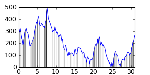
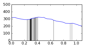
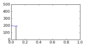
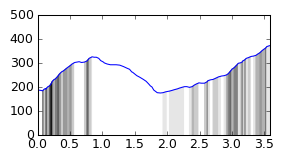
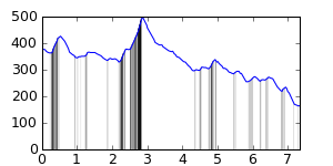
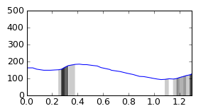
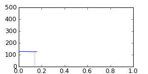
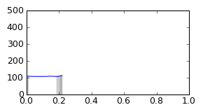
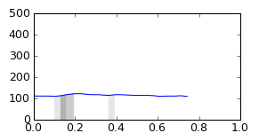
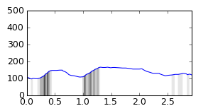
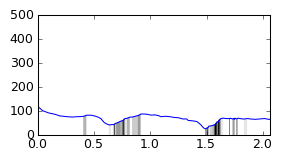
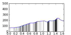
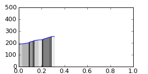
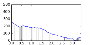
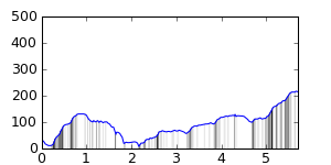
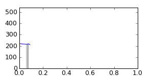
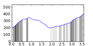
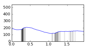
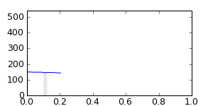
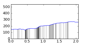
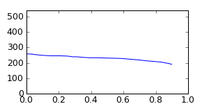
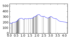
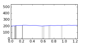
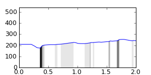
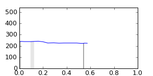
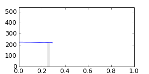
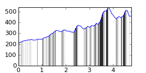
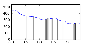
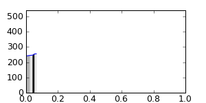
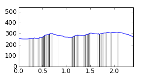
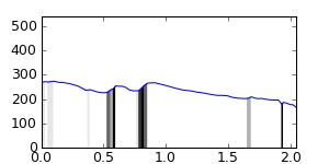
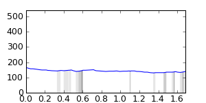
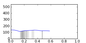
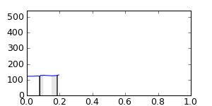
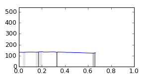
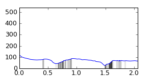
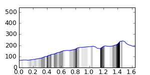
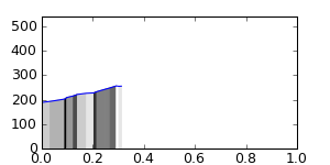
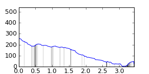
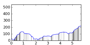
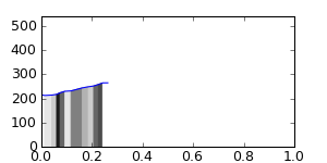
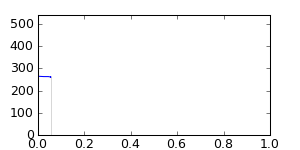
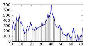
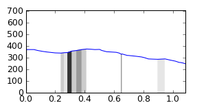
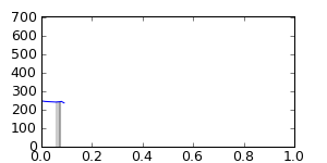
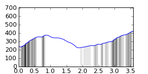
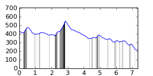
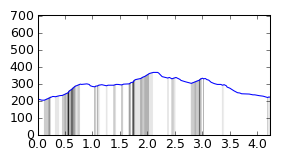
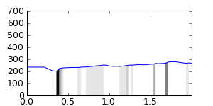
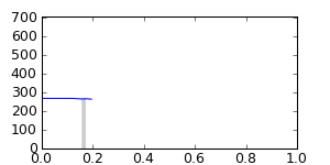
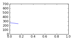
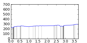
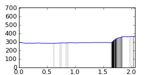
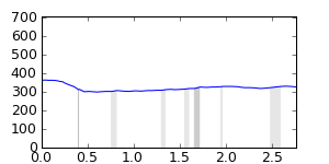
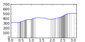
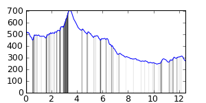
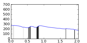
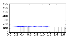
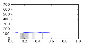
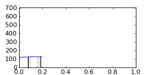
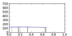
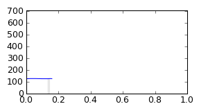
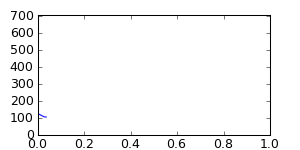
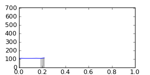
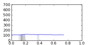
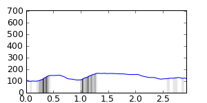
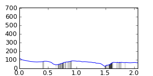
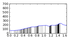
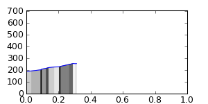
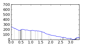
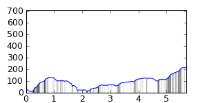
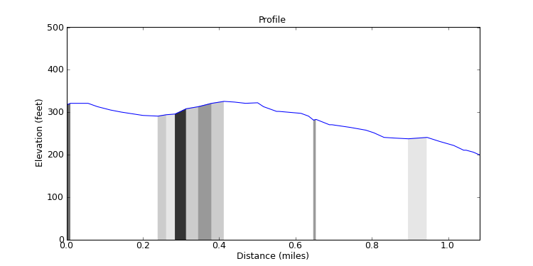
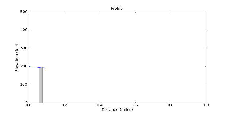
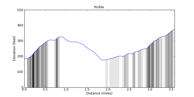
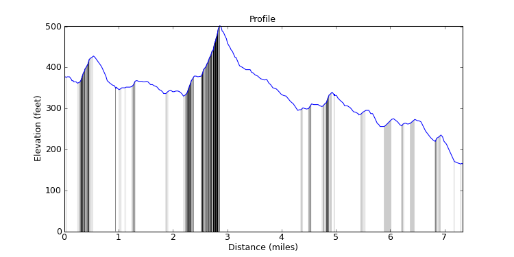
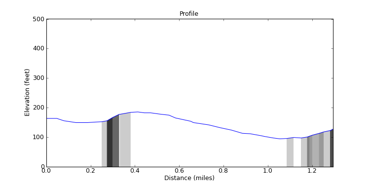
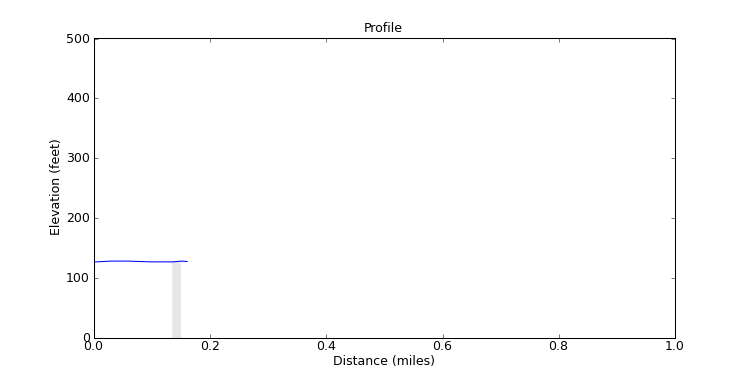
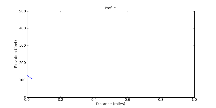
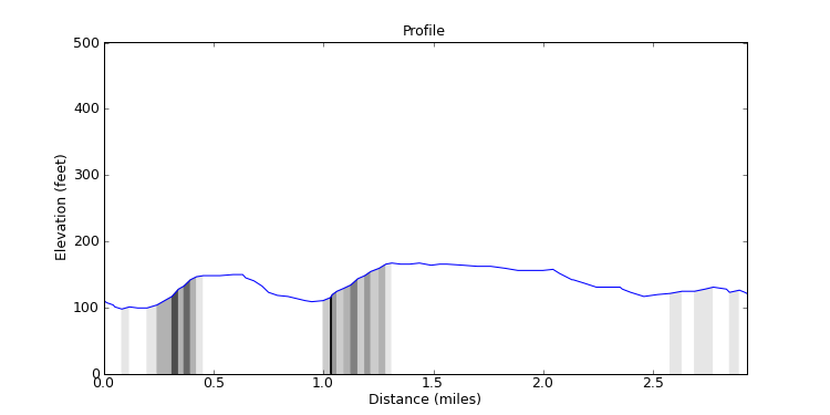
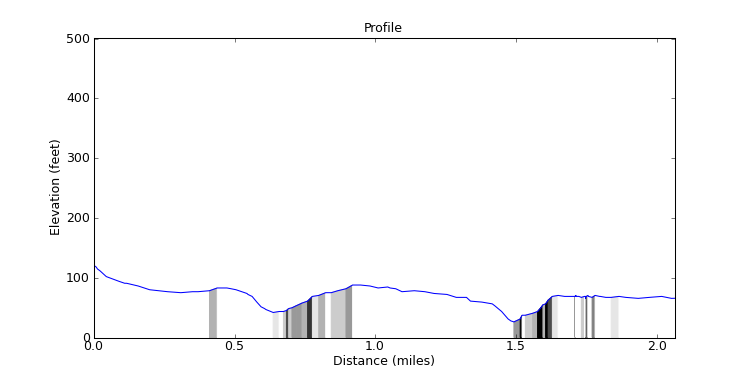
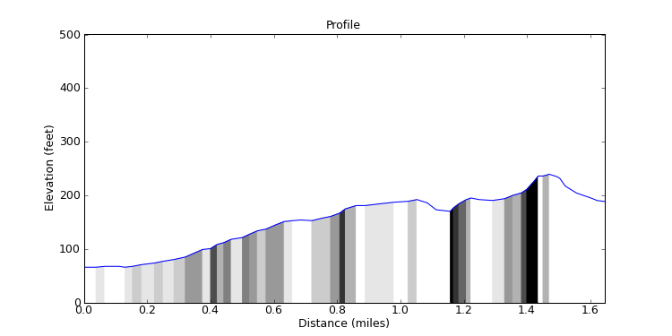
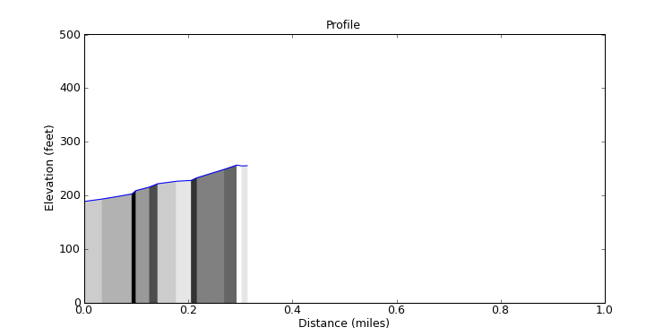
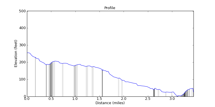
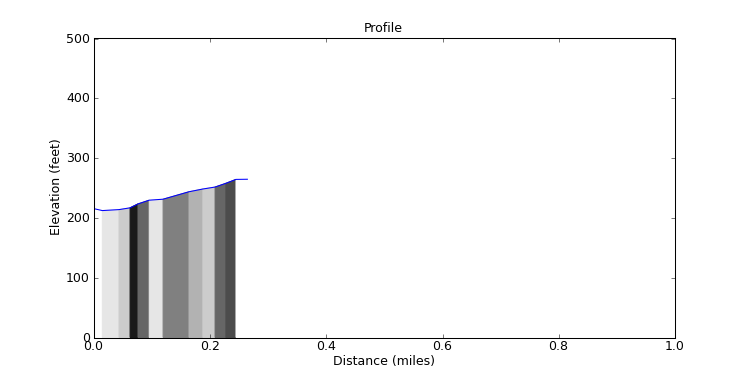
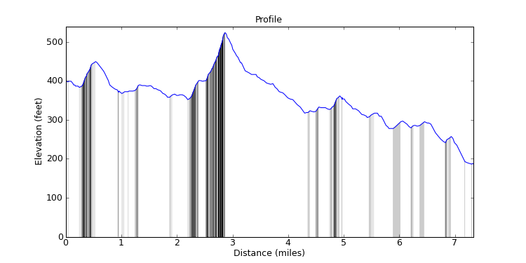
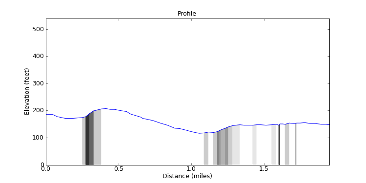
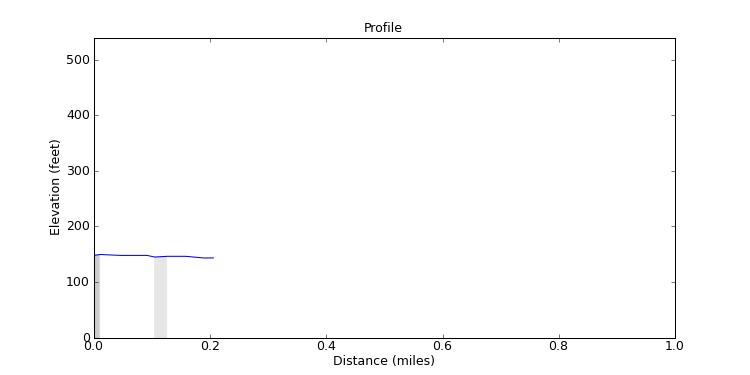
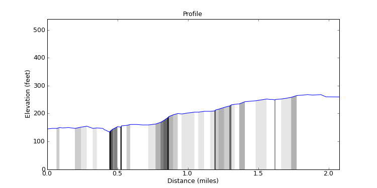
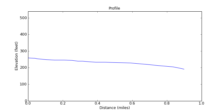
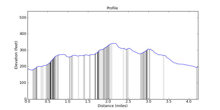
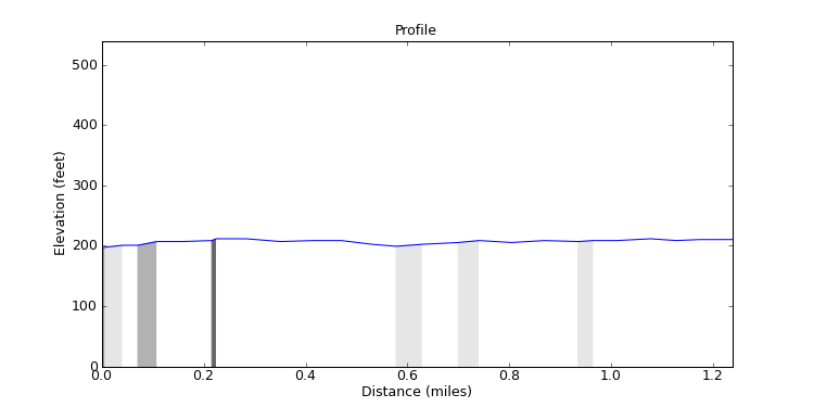
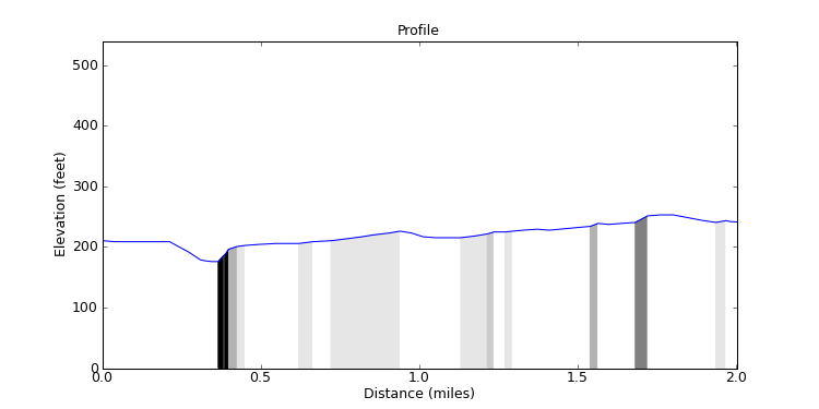
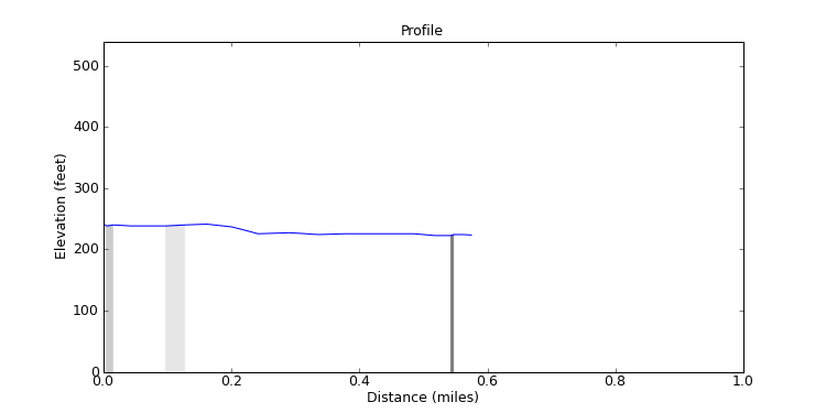
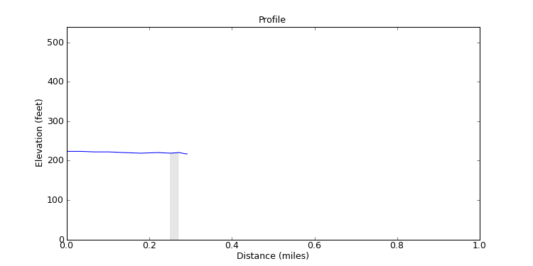
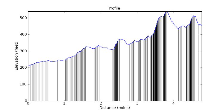
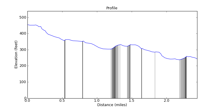
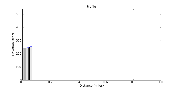
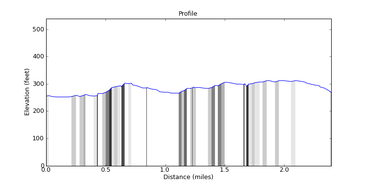
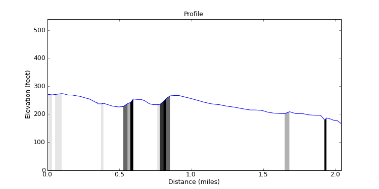
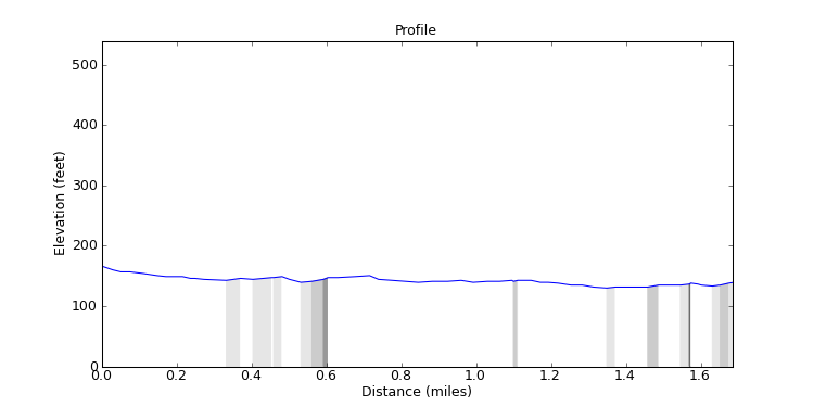
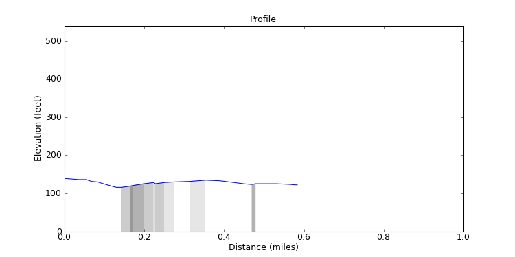
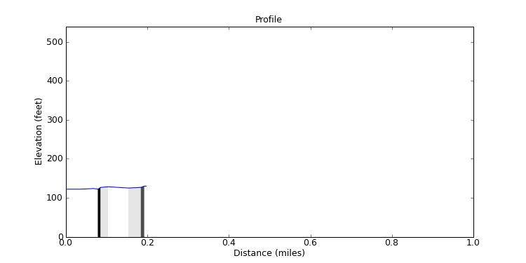
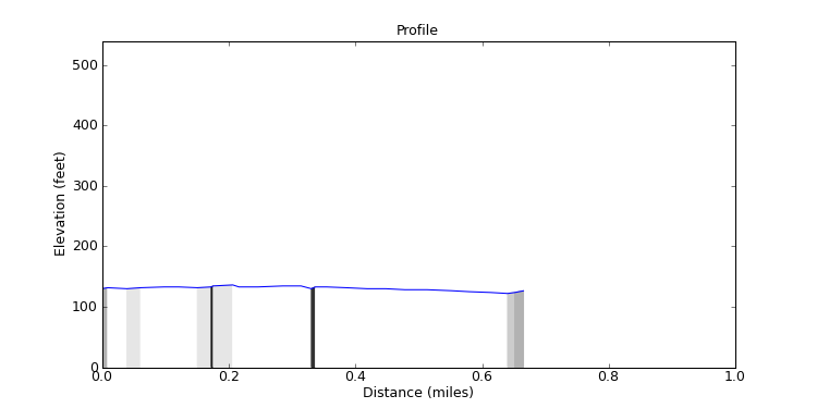
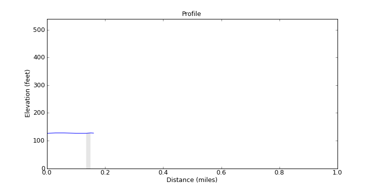
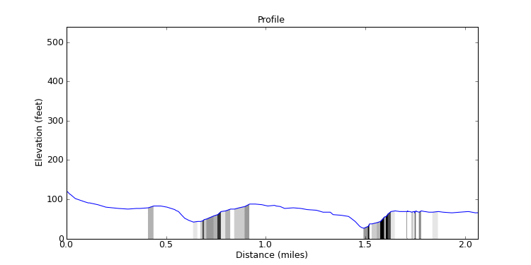
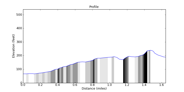
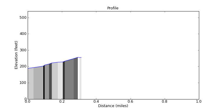
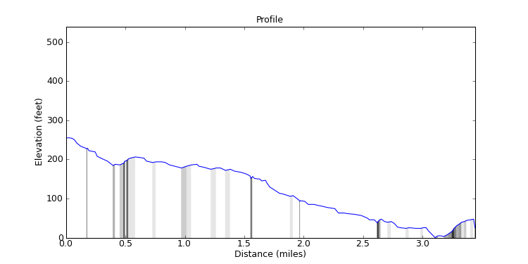
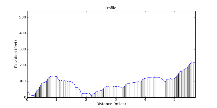
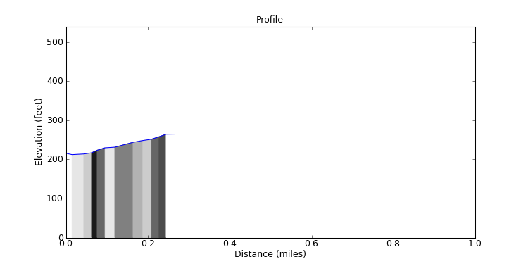
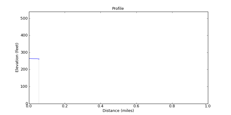
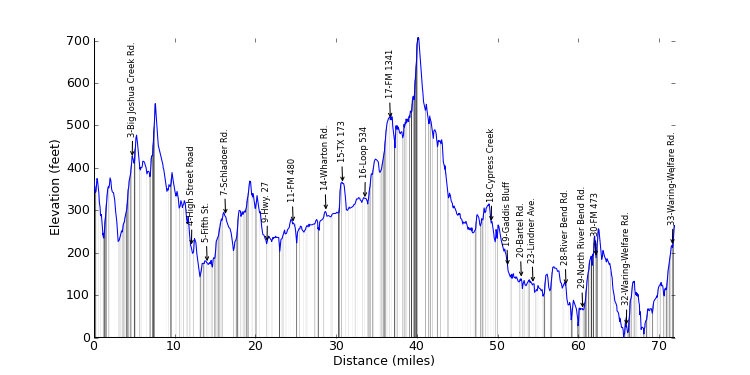
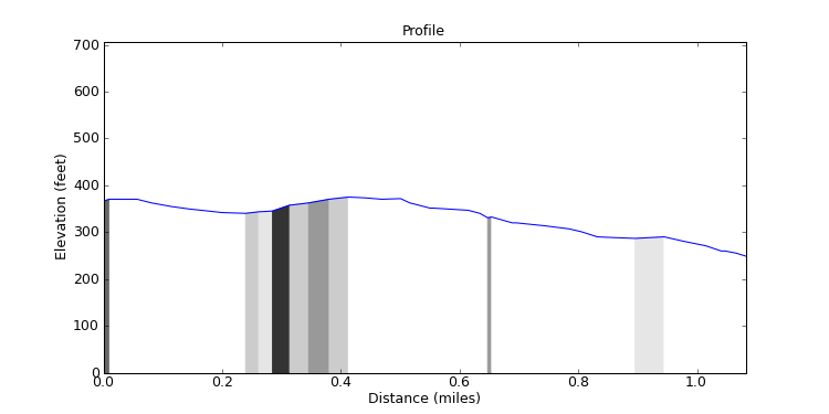
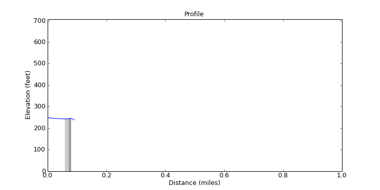
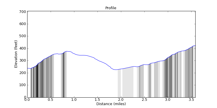
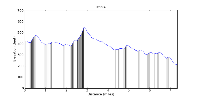
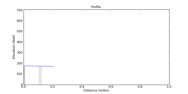
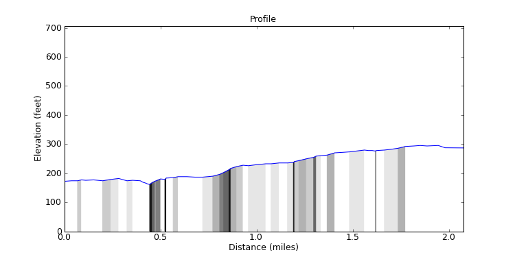
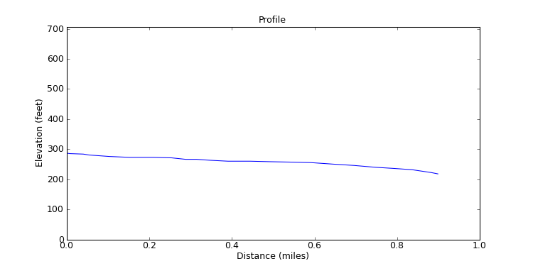
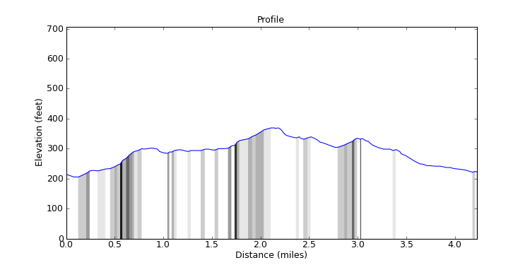
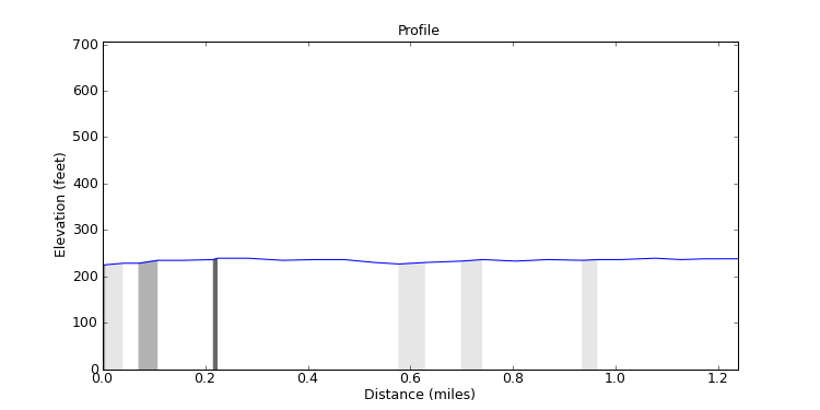
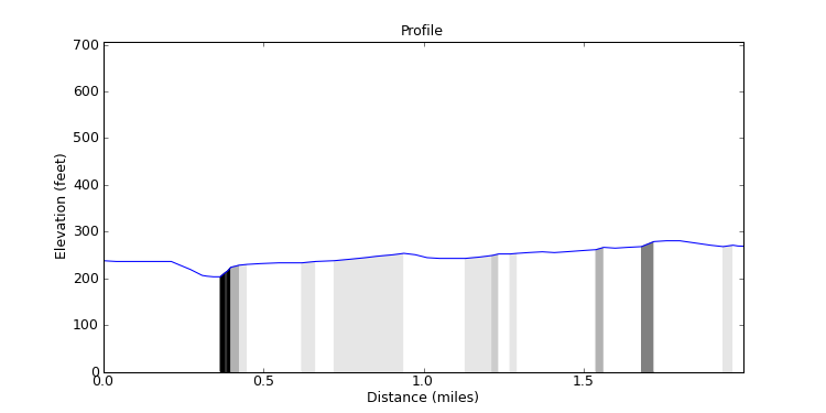
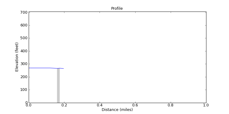
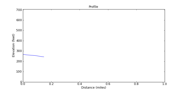
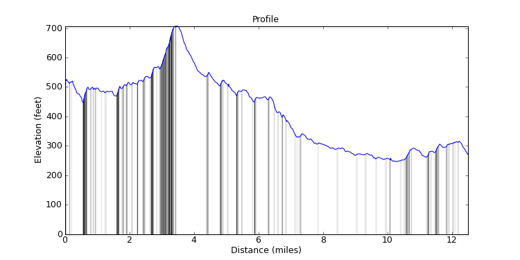
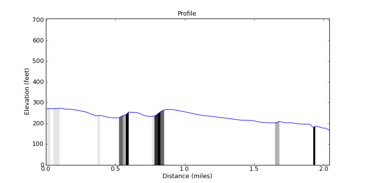
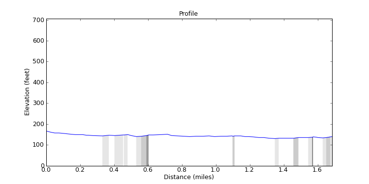
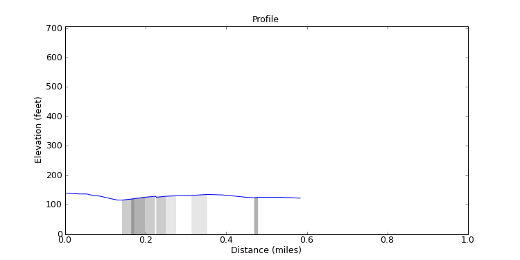
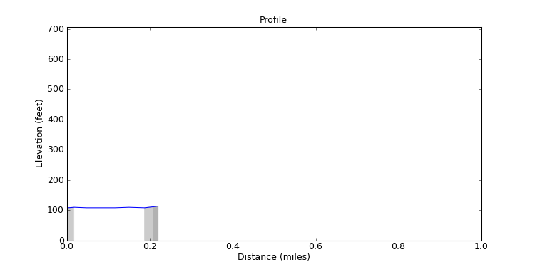
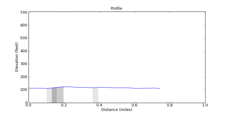
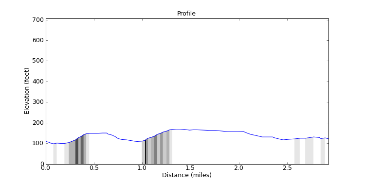
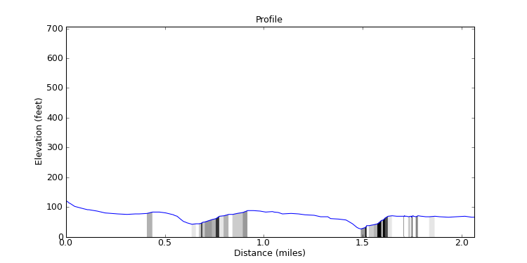
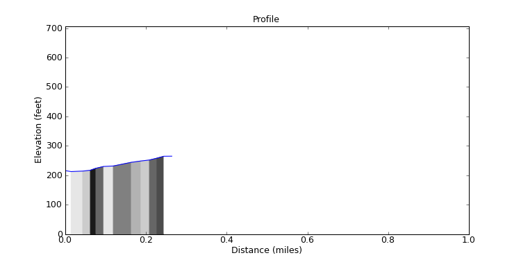
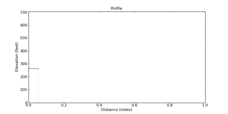
This is an analysis of the elevation data for the ride and for each of the segments of the ride.
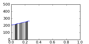
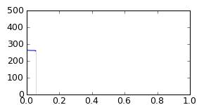
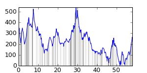
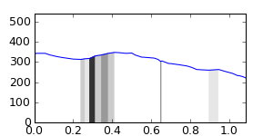
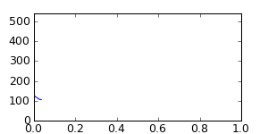
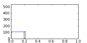
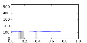
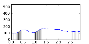
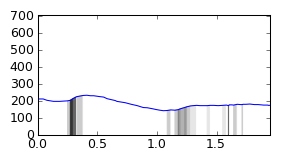
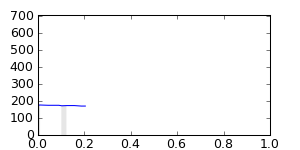
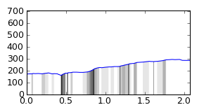
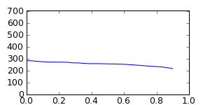
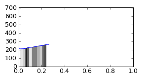
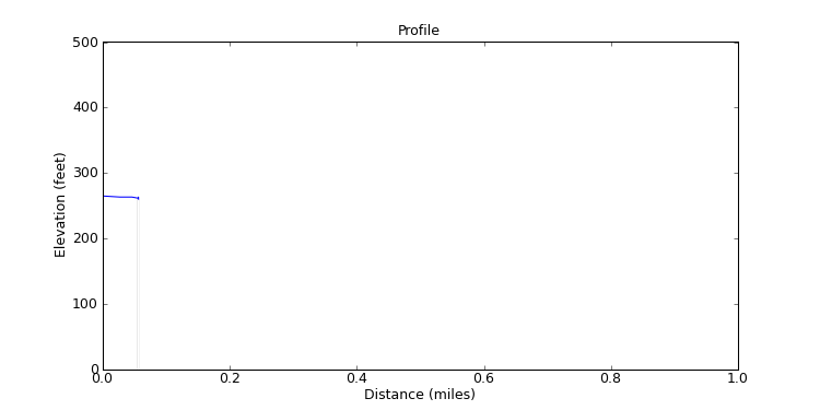
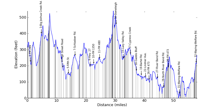
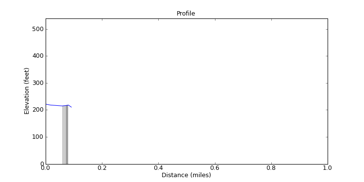
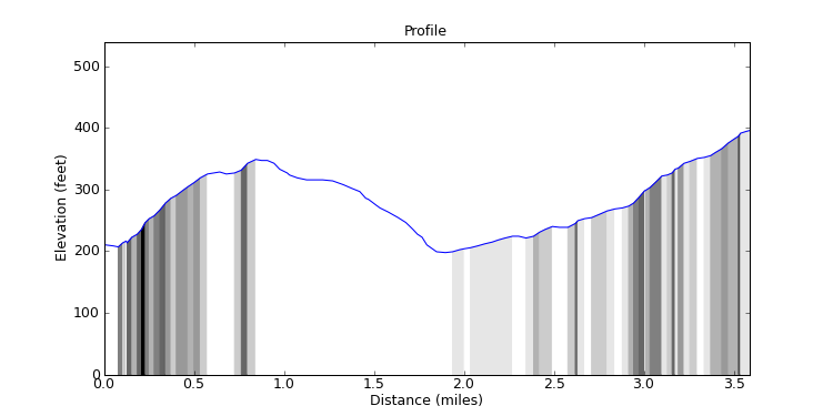
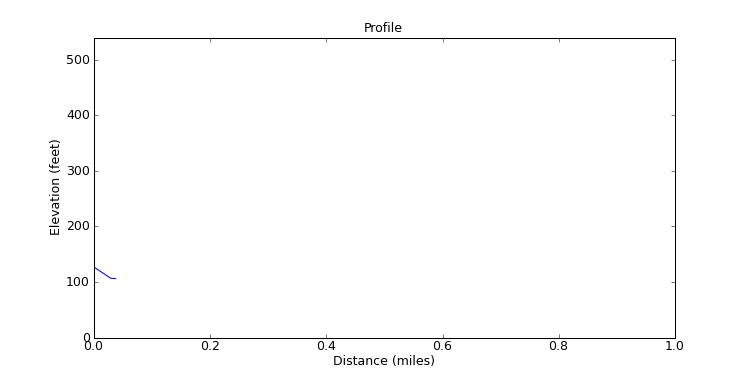
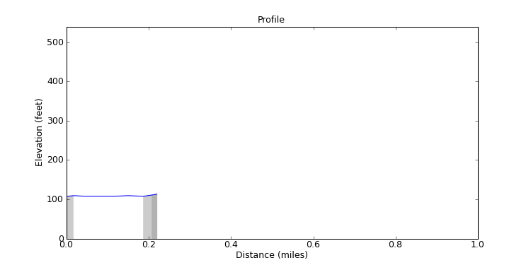
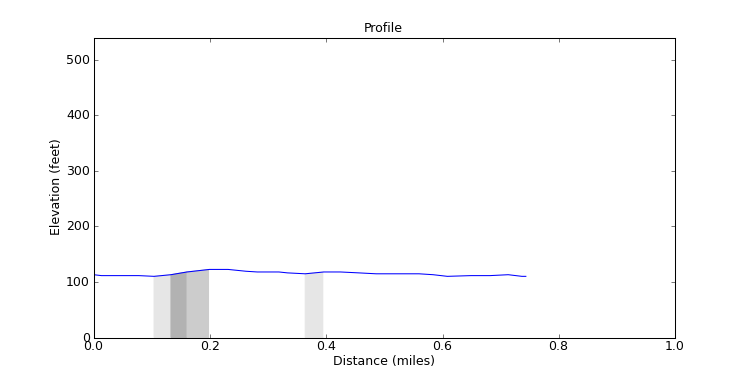
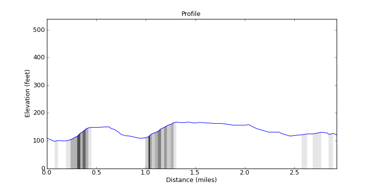
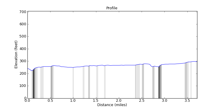
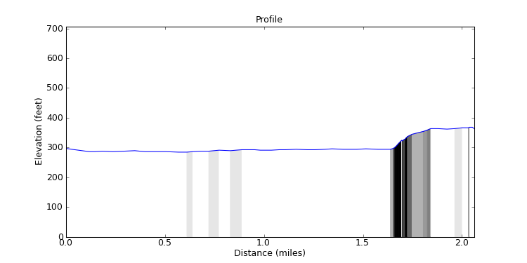
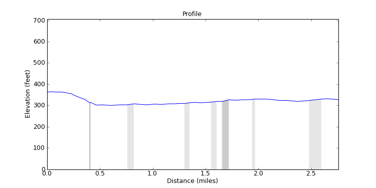
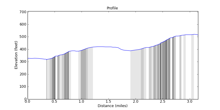
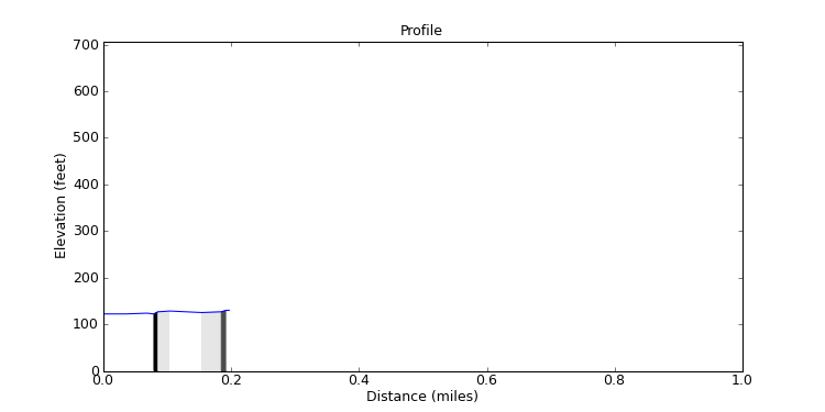
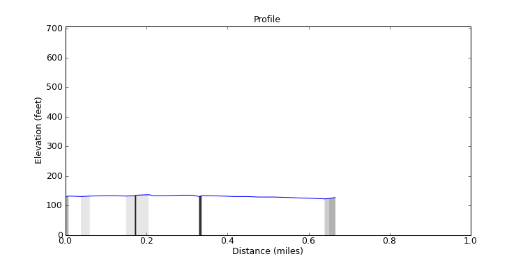
The graphs show the elevation profiles. They are shaded underneath to show how steep each part of the ride is, lighter for less steep all the way to black for very steep. I normalize the height so you see elevations from 0 to the tallest point on the ride. I don't put the true elevation above sea level because, for the San Antonio area, elevation above sea level isn't very interesting since we're never high enough to make a difference. Also, you can click on a graph to see a larger version of it. The larger graph will pop up in a separate window.
The ride and segment analyses show how much climbing and descending you'll do in the ride or segment and what the average grade is for each. The climb list tells you how steep and how long the worst climbs in the ride or segment are, and is ranked by steepness.